
Mappa topografica Saughall
Clicca sulla mappa per visualizzare l'altitudine.
A proposito di questa mappa
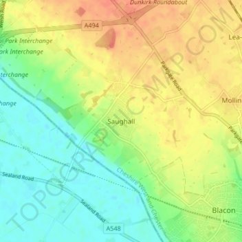
Nome: Mappa topografica Saughall, altitudine, rilievo.
Altitudine media: 22 m
Altitudine minima: 2 m
Altitudine massima: 44 m
Altre mappe topografiche
Clicca su una mappa per visualizzarne la topografia, l'altitudine e il rilievo.
Great Boughton
United Kingdom > England > Cheshire West and Chester > Great Boughton
Altitudine media: 28 m
Countess of Chester Country Park
United Kingdom > England > Cheshire West and Chester > Chester
Altitudine media: 21 m
Burwardsley
United Kingdom > England > Cheshire West and Chester > Burwardsley
Altitudine media: 113 m
Frodsham
United Kingdom > England > Cheshire West and Chester
Several faults run roughly northwest–southeast through the area, notably the Overton Fault, which roughly parallels the B5439 and B5152 roads, and the Frodsham Fault, which runs north from the vicinity of Crowmere to the mouth of the River Weaver. Both of these faults and others in the area downthrow to the…
Altitudine media: 49 m
Bolesworth Fish Pond
United Kingdom > England > Cheshire West and Chester > Harthill > Broxton
Altitudine media: 75 m
Wirral Country Park
United Kingdom > England > Cheshire West and Chester > Neston > Windle Hill
Altitudine media: 49 m
Peckforton Castle
United Kingdom > England > Cheshire West and Chester > Beeston
Peckforton Castle stands in a wooded area near the northern extremity of Peckforton Hills at an elevation of 469.2 feet (143 m). The land falls steeply downwards to the north and the west of the castle, and the Sandstone Trail, a long-distance footpath, runs along the base of these slopes. The ruins of Beeston…
Altitudine media: 83 m
Little Stanney
United Kingdom > England > Cheshire West and Chester > Ellesmere Port
Altitudine media: 21 m
Dutton Small Lock (Disused)
United Kingdom > England > Cheshire West and Chester > Acton Bridge > Dutton
Altitudine media: 28 m
Little Leigh
United Kingdom > England > Cheshire West and Chester > Little Leigh
Altitudine media: 38 m
Black Diamond Park
United Kingdom > England > Cheshire West and Chester > Chester
Altitudine media: 21 m