
Fai una donazione
Equipaggiati per la tua prossima avventura:
In qualità di Affiliato Amazon, questo sito riceve una commissione sugli acquisti idonei, senza costi aggiuntivi per l’utente.
Mappa topografica Loktak Lake
Clicca sulla mappa per visualizzare l'altitudine.
Fai una donazione
Equipaggiati per la tua prossima avventura:
In qualità di Affiliato Amazon, questo sito riceve una commissione sugli acquisti idonei, senza costi aggiuntivi per l’utente.
Loktak Lake
At the Ithai barrage outlet of the Lake, the direct catchment area draining into the lake is 980 km2 (380 sq mi) out of which 430 km2 (170 sq mi) is under paddy cultivation, 150 km2 (58 sq mi) under habitation and 400 km2 (150 sq mi) under forest cover. The area of the lake is 236.21 km2 (91.20 sq mi), comprising large pockets of open water and marshy land formed at the southern part of the Imphal valley up to the confluence of Manipur River and Khuga River in the district of Imphal West. The Lake is divided into two zones, namely, the "Core Zone" which is the no-development zone or totally protected zone comprising 70.3 km2 (27.1 sq mi) and the balance area is called the "Buffer Zone". Within the lake and on its periphery, there are 14 hills of varying size and elevation; in the southern part of the lake are the Sendra, Ithing and Thanga islands.
Fai una donazione
Equipaggiati per la tua prossima avventura:
In qualità di Affiliato Amazon, questo sito riceve una commissione sugli acquisti idonei, senza costi aggiuntivi per l’utente.
A proposito di questa mappa
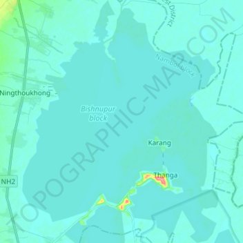
Nome: Mappa topografica Loktak Lake, altitudine, rilievo.
Luogo: Loktak Lake, Moirang, Bishnupur, Manipur, India (24.50344 93.76331 24.61392 93.86137)
Altitudine media: 771 m
Altitudine minima: 762 m
Altitudine massima: 876 m
Fai una donazione
Equipaggiati per la tua prossima avventura:
In qualità di Affiliato Amazon, questo sito riceve una commissione sugli acquisti idonei, senza costi aggiuntivi per l’utente.