
Mappa topografica Forfar
Clicca sulla mappa per visualizzare l'altitudine.
A proposito di questa mappa
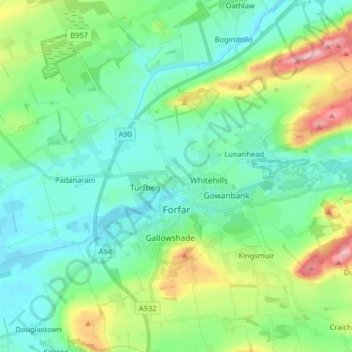
Nome: Mappa topografica Forfar, altitudine, rilievo.
Luogo: Forfar, Angus, Scotland, United Kingdom (56.60820 -2.96020 56.69719 -2.80990)
Altitudine media: 95 m
Altitudine minima: 51 m
Altitudine massima: 227 m
Altre mappe topografiche
Clicca su una mappa per visualizzarne la topografia, l'altitudine e il rilievo.
Kirriemuir
United Kingdom > Scotland > Angus
The family estate of Sir Hugh Munro, who created Munro's Tables of Scottish mountains over 3,000 ft. in elevation (which are now called "munros"), is also located near the town.
Altitudine media: 123 m
Montrose
United Kingdom > Scotland > Angus
Montrose occupies a position on the North Bank of Montrose Basin at the mouth of the River South Esk on the East Coast of Scotland, 11 miles (18 km) NNE of Arbroath, 19 miles (31 km) SW of Stonehaven, and 7.2 miles (12 km) ESE of Brechin. The town lies 62.2 miles (100 km) NNE of Edinburgh, and 373.2 miles (601…
Altitudine media: 22 m
Cairn of Claise
United Kingdom > Scotland > Angus
It has an elevation of 1,063.1 m (3,488 ft) and a prominence of 118.9 m (390 ft) and is a Munro.
Altitudine media: 919 m
Kirriemuir
United Kingdom > Scotland > Angus
The family estate of Sir Hugh Munro, who created Munro's Tables of Scottish mountains over 3,000 feet (914.4 metres) in elevation (which are now called "munros"), is also located near the town.
Altitudine media: 123 m
Montrose
United Kingdom > Scotland > Angus
Montrose occupies a position on the North Bank of Montrose Basin at the mouth of the River South Esk on the East Coast of Scotland, 11 miles (18 km) NNE of Arbroath, 19 miles (31 km) SW of Stonehaven, and 7.2 miles (12 km) ESE of Brechin. The town lies 62.2 miles (100 km) NNE of Edinburgh, and 373.2 miles (601…
Altitudine media: 22 m