
Mappa topografica Montrose
Clicca sulla mappa per visualizzare l'altitudine.
Montrose
Montrose occupies a position on the North Bank of Montrose Basin at the mouth of the River South Esk on the East Coast of Scotland, 11 miles (18 km) NNE of Arbroath, 19 miles (31 km) SW of Stonehaven, and 7.2 miles (12 km) ESE of Brechin. The town lies 62.2 miles (100 km) NNE of Edinburgh, and 373.2 miles (601 km) NNW of London. The built-up area occupies a roughly rectangular shape 2 miles (3 km) long by 0.75 miles (1 km) wide, aligned in a north–south orientation. The land is relatively flat, rising gradually to around 15m elevation to the North of the town.
A proposito di questa mappa
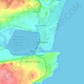
Nome: Mappa topografica Montrose, altitudine, rilievo.
Luogo: Montrose, Angus, Scotland, DD10 8QZ, United Kingdom (56.67143 -2.50815 56.75143 -2.42815)
Altitudine media: 22 m
Altitudine minima: -2 m
Altitudine massima: 135 m
Altre mappe topografiche
Clicca su una mappa per visualizzarne la topografia, l'altitudine e il rilievo.