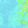
Mappa topografica Ernakulam district
Clicca sulla mappa per visualizzare l'altitudine.
Ernakulam district
The Ernakulam district covers an area of 3,068 km2 (1,185 sq mi) on the Western Coastal Plains of India. It is surrounded by the Thrissur District to the north, the Idukki District to the east, Alappuzha and Kottayam districts to the south and the Laccadive Sea to the west. The Anamalais occupy a large part of the district, consisting of the forest areas around Pooyamkutty and the Idamalayar Dam. The range also extends into Thrissur, Palakkad, and Idukki districts, as well as Coimbatore and Tiruppur districts of Tamil Nadu. The district is divided geographically into highland, midland, and coastal area. The altitude of the highlands is about 300 m (980 ft). The Periyar River, Kerala's longest, flows through all the taluks except Muvattupuzha. The Muvattupuzha River and a branch of the Chalakkudy River also flow through the district. The average yearly rainfall in the district is 3,432 mm (135.1 in). The district has a moderate climate and mostly falls within the Malabar Coast moist forests ecoregion, while the highlands are part of the South Western Ghats moist deciduous forests ecoregion. The Anamudi is the tallest peak in South India, on the border of Ernakulam and Idukki districts. Some parts of the Idamalayar Reserve Forest and Mankulam Forest Division have Sholas but these parts are inaccessible by road. Ernakulam district does not have a border with Tamil Nadu in some maps the district is shown incorrectly by adding areas of Idukki (which share border with Tamil nadu) as regions of Ernakulam. The Idamalayar Reserve Forest, and Edamalakkudy. Many types of sand, soil, and rocks are abundant here. Cochin International Airport is located in the northern part of the district at Nedumbassery, Kochi.
A proposito di questa mappa
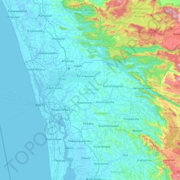
Nome: Mappa topografica Ernakulam district, altitudine, rilievo.
Luogo: Ernakulam district, Kerala, India (9.77369 76.16284 10.30322 77.08893)
Altitudine media: 201 m
Altitudine minima: -4 m
Altitudine massima: 1’826 m
Altre mappe topografiche
Clicca su una mappa per visualizzarne la topografia, l'altitudine e il rilievo.
Kottayam
Kottayam has an average elevation of 3 metres (9.8 ft) above sea level. and is situated in the basin of the Meenachil River and in the basin of the Vembanad backwaters, which are formed from several streams in the Western Ghats in Idukki district. According to the division of places in Kerala based on…
Altitudine media: 19 m
Thiruvalla
India > Kerala > Thiruvalla
Thiruvalla lies at an altitude of 9 meters above sea level on the basin of the Pamba and Manimala rivers. Thiruvalla is dotted with several natural canal streams (called "thodu" in Malayalam) like Chanthathodu, Manippuzha, Mullelithodu, and several others. The city area has riverine alluvial soil, and eastern…
Altitudine media: 10 m

Vadakara
Vatakara is located at 11°36′N 75°35′E / 11.60°N 75.58°E / 11.60; 75.58 and has an average elevation of 15 m (49 ft). It is situated about 49 km to the north of Kozhikode City, approximately 44 km to the south of Kannur City, and adjacent to Mahé. The town lies by the side of a river…
Altitudine media: 12 m
Thrippunithura
India > Kerala > Kanayannur
In the south, Thrippunithura borders the Vembanad, the longest lake in India. The lake provides facilities for inland water navigation, with the Champakkara canal stretch of the National Waterway 3 forming its western boundary with Kochi and Maradu. The canal then merges with the Chithrapuzha river in the…
Altitudine media: 8 m
Upputhara
Upputhara is a village in Idukki district in the Indian state of Kerala. Upputhara panchayat, belonging to the block panchayat of Kattappana, is situated in the southern part of Idukki district in the Peermade taluk. The panchayat is bordered by the Periyar River in the east, the Meenmutti Lake in the west,…
Altitudine media: 801 m




Periyar National Park Tiger Reserve
Periyar National Park lies in the middle of a mountainous area of the Cardamom Hills. In the north, the boundary commences from the point nearest to the Medaganam in the interstate boundary up to Vellimalai. To the east the boundary follows the inter-state boundary from Vellimalai to Kallimalai Peak (1615 m)…
Altitudine media: 929 m
Muvattupuzha
India > Kerala > Muvattupuzha
The town and western parts of the region are mainly plains and is culturally similar to Ernakulam, whereas the eastern parts are mainly highlands. The regions of Thodupuzha, Muvattupuzha, and Kothamangalam are called sub-high ranges or keezhmalanad of Vadakkumkoor Kingdom, indicating they were lands with…
Altitudine media: 44 m


Pathanamthitta
Pathanamthitta has an average elevation of 18 metres (62 ft) above sea level.
Altitudine media: 63 m
Ponkunnam
India > Kerala > Kanjirappally
Ponkunnam is a census town in Kerala, India, part of Kottayam district under Kanjirappally taluk. Ponkunnam literally means golden mountain (ponn = gold, kunn = mountain). Nearby towns are Kanjirappalli, Pampady , Manimala and Pala. This part of Kerala is famous for its fertile land and rubber plantations. It…
Altitudine media: 83 m


Payyanur
India > Kerala > Payyannur Taluk
Payyanur is located at coordinates 12°06′N 75°12′E / 12.1°N 75.2°E / 12.1; 75.2. It has an average elevation of 16 metres (51 feet).
Altitudine media: 8 m


Angamoozhy
Angamoozhy is geographically a high-range area (Malanadu) situated in the south eastern part of Kerala and very close to the Western ghats mountain ranges. It has an average elevation of 18 m (59 ft) above sea level.
Altitudine media: 233 m










Kallooppara
India > Kerala > Mallappally
The old Vemolinad was separated into "Vadakumkoor" and "Thekkumkoor" in AD 1100. Kottayam, Chenganacherry, Thiruvalla, Kanjirapally and some places of high range were included in Thekkumkoor kingdom. Kallooppara was under the control of the Thekkumkoor dynasty. It had Kalari (training center for martial arts)…
Altitudine media: 19 m