
Fai una donazione
Equipaggiati per la tua prossima avventura:
In qualità di Affiliato Amazon, questo sito riceve una commissione sugli acquisti idonei, senza costi aggiuntivi per l’utente.
Mappa topografica Upputhara
Clicca sulla mappa per visualizzare l'altitudine.
Fai una donazione
Equipaggiati per la tua prossima avventura:
In qualità di Affiliato Amazon, questo sito riceve una commissione sugli acquisti idonei, senza costi aggiuntivi per l’utente.
Upputhara
Upputhara is a village in Idukki district in the Indian state of Kerala. Upputhara panchayat, belonging to the block panchayat of Kattappana, is situated in the southern part of Idukki district in the Peermade taluk. The panchayat is bordered by the Periyar River in the east, the Meenmutti Lake in the west, the Chinnar River and the Karintharuvi River in the south and the Kakkathode protected forests in the north. Upputhara is located in the Western Ghats region of Kerala that borders on the neighbouring State of Tamil Nadu. Geographically, Upputhara is divided into six types of land forms; mountains, highly steep land, moderately steep land, valleys, marshy lands and rocky lands. Of these six land forms, about 40 percent of the total area is classified under valleys. Next in importance are marshy lands, slightly steep land, mountains, very steep land and rocky lands, in that order. Valleys and marshy lands together accounted for 62 percent of the area. Owing to the presence of large tracts of land with undulating topography, agriculture in Upputhara is faced with several challenges such as soil erosion.
Fai una donazione
Equipaggiati per la tua prossima avventura:
In qualità di Affiliato Amazon, questo sito riceve una commissione sugli acquisti idonei, senza costi aggiuntivi per l’utente.
A proposito di questa mappa
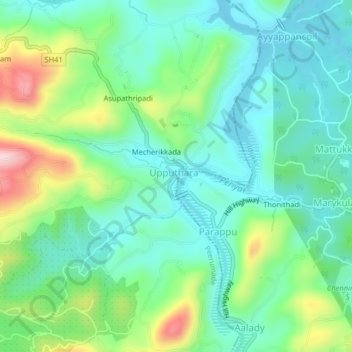
Nome: Mappa topografica Upputhara, altitudine, rilievo.
Luogo: Upputhara, Idukki, Kerala, 685507, India (9.67952 77.00120 9.71952 77.04120)
Altitudine media: 801 m
Altitudine minima: 718 m
Altitudine massima: 1’010 m
Fai una donazione
Equipaggiati per la tua prossima avventura:
In qualità di Affiliato Amazon, questo sito riceve una commissione sugli acquisti idonei, senza costi aggiuntivi per l’utente.