
Mappa topografica Winnipeg
Clicca sulla mappa per visualizzare l'altitudine.
Winnipeg
Winnipeg lies at the bottom of the Red River Valley, a flood plain with an extremely flat topography. It is on the eastern edge of the Canadian Prairies in Western Canada and is known as the "Gateway to the West". Winnipeg is bordered by tallgrass prairie to the west and south and the aspen parkland to the northeast, although most of the native prairie grasses have been removed for agriculture and urbanization. It is relatively close to many large Canadian Shield lakes and parks, as well as Lake Winnipeg (the Earth's 11th largest freshwater lake). Winnipeg has North America's largest extant mature urban elm forest. The city has an area of 464.08 km2 (179.18 sq mi).
A proposito di questa mappa
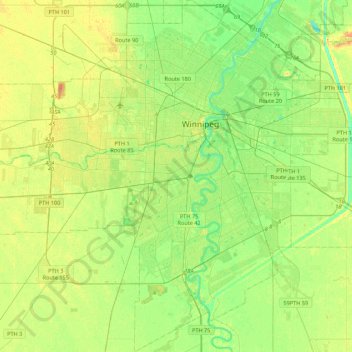
Nome: Mappa topografica Winnipeg, altitudine, rilievo.
Luogo: Winnipeg, Manitoba, Canada (49.71355 -97.34915 49.99401 -96.95653)
Altitudine media: 236 m
Altitudine minima: 222 m
Altitudine massima: 261 m
Altre mappe topografiche
Clicca su una mappa per visualizzarne la topografia, l'altitudine e il rilievo.
Lockport
Canada > Manitoba > Division No. 13 > Rural Municipality of St. Andrews
Altitudine media: 232 m
Red River Floodway
Canada > Manitoba > Rural Municipality of Springfield > Winnipeg
Altitudine media: 236 m
Little Saskatchewan First Nation
Canada > Manitoba > Little Saskatchewan First Nation
Altitudine media: 247 m
North Thomas Lake
Canada > Manitoba > Division No. 15 > Rural Municipality of Yellowhead
Altitudine media: 596 m
Hecla
Canada > Manitoba > Division No. 18 > Unorganized Division No. 18 (East)
Altitudine media: 220 m
Clear Lake
Canada > Manitoba > Division No. 18 > Rural Municipality of Grahamdale
Altitudine media: 251 m
Riding Mountain National Park
The climate in the Riding Mountain region is similar to that of other regions of southwestern Manitoba. Under the Köppen classification it has a continental climate. It includes grasslands, upland boreal and eastern deciduous forest ecosystems. The park has hot summers and cold winters, with annual rainfall…
Altitudine media: 488 m
Rowland Lake
Canada > Manitoba > Division No. 15 > Rural Municipality of Rosedale
Altitudine media: 692 m
Bakers Narrows
Canada > Manitoba > Division No. 21 > Unorganized Division No. 21
Altitudine media: 297 m
Elphinstone
Canada > Manitoba > Division No. 15 > Rural Municipality of Yellowhead
Altitudine media: 583 m
West Hawk Lake
Canada > Manitoba > Division No. 1 > Unorganized Division No. 1
Altitudine media: 349 m