
Fai una donazione
Equipaggiati per la tua prossima avventura:
In qualità di Affiliato Amazon, questo sito riceve una commissione sugli acquisti idonei, senza costi aggiuntivi per l’utente.
Mappa topografica Aluva
Clicca sulla mappa per visualizzare l'altitudine.
Fai una donazione
Equipaggiati per la tua prossima avventura:
In qualità di Affiliato Amazon, questo sito riceve una commissione sugli acquisti idonei, senza costi aggiuntivi per l’utente.
Aluva
Aluva Railway Station is a major stop for trains that passes north to south of Kerala. It is the third busiest station in Kochi city, after Ernakulam Junction railway station and Ernakulam Town railway station. The station is important for southern railway because of the number of passengers itself. The commuters and travellers from Idukki district have to use either this station or the Tripunithura railway station for all their train journeys as there is no possible railway in the Idukki topography. There are no trains starting or ending at this station, but there are a lot of trains which stop for considerable duration here.
Fai una donazione
Equipaggiati per la tua prossima avventura:
In qualità di Affiliato Amazon, questo sito riceve una commissione sugli acquisti idonei, senza costi aggiuntivi per l’utente.
A proposito di questa mappa
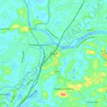
Nome: Mappa topografica Aluva, altitudine, rilievo.
Luogo: Aluva, Ernakulam, Kerala, 683101, India (10.06777 76.31685 10.14777 76.39685)
Altitudine media: 11 m
Altitudine minima: -2 m
Altitudine massima: 52 m
Fai una donazione
Equipaggiati per la tua prossima avventura:
In qualità di Affiliato Amazon, questo sito riceve una commissione sugli acquisti idonei, senza costi aggiuntivi per l’utente.
Altre mappe topografiche
Clicca su una mappa per visualizzarne la topografia, l'altitudine e il rilievo.