
Mappa topografica Kumily
Clicca sulla mappa per visualizzare l'altitudine.
A proposito di questa mappa
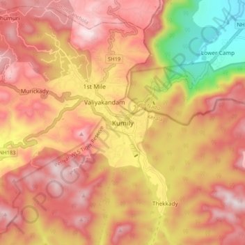
Nome: Mappa topografica Kumily, altitudine, rilievo.
Luogo: Kumily, Peerumade, Idukki, Kerala, 685509, India (9.56680 77.12710 9.64680 77.20710)
Altitudine media: 936 m
Altitudine minima: 454 m
Altitudine massima: 1’231 m
Altre mappe topografiche
Clicca su una mappa per visualizzarne la topografia, l'altitudine e il rilievo.
Periyar National Park Tiger Reserve
Periyar National Park lies in the middle of a mountainous area of the Cardamom Hills. In the north : The boundary commences from the point nearest to the Medaganam in the interstate boundary up to Vellimalai. and the east Thence the boundary follows the inter-state boundary from Vellimalai to Kallimalai Peak…
Altitudine media: 929 m