
Mappa topografica Koksilah
Clicca sulla mappa per visualizzare l'altitudine.
A proposito di questa mappa
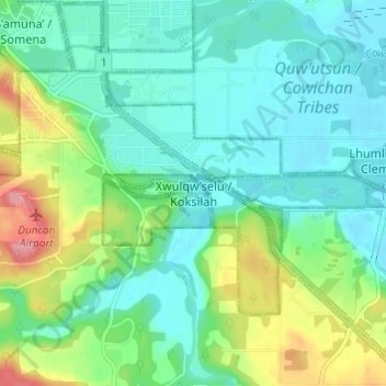
Nome: Mappa topografica Koksilah, altitudine, rilievo.
Luogo: Koksilah, British Columbia, V9L 6W3, Canada (48.73691 -123.70483 48.77691 -123.66483)
Altitudine media: 29 m
Altitudine minima: 0 m
Altitudine massima: 105 m
Altre mappe topografiche
Clicca su una mappa per visualizzarne la topografia, l'altitudine e il rilievo.
Vancouver
Canada > British Columbia > Metro Vancouver Regional District
Vancouver, British Columbia, is situated on the Burrard Peninsula, bordered by Burrard Inlet to the north and the Fraser River to the south. The city's topography is a blend of flat and hilly terrains, with elevations ranging from sea level to approximately 152 meters (500 feet) above sea level. The North…
Altitudine media: 34 m
Victoria
Canada > British Columbia > Capital Regional District
Victoria, British Columbia, is situated on the southern tip of Vancouver Island, Canada, and boasts a diverse and varied topography. The city is characterized by rolling hills, rugged coastal cliffs, and lush valleys, providing a striking contrast between mountainous terrain and flatland areas. To the north…
Altitudine media: 17 m
Vancouver Island
The rain shadow effect of the island's mountains, as well as the mountains of Washington's Olympic Peninsula, creates wide variation in precipitation. The west coast is considerably wetter than the east coast. Average annual precipitation ranges from 6,650 mm (262 in) at Hucuktlis Lake on the west coast…
Altitudine media: 411 m
Kelowna
Canada > British Columbia > Regional District of Central Okanagan
Kelowna is classified as a humid continental climate or an inland oceanic climate per the Köppen climate classification system due to its coldest month having an average temperature slightly above −3.0 °C (26.6 °F) and below 0 °C (32 °F), with dry, hot, sunny summers and cool, cloudy winters, and four…
Altitudine media: 704 m
Prince George
Canada > British Columbia > Regional District of Fraser-Fort George
The area has a humid continental climate (Köppen climate classification Dfb, Trewartha Dclo), but is close to (and once had) a subarctic climate (Dfc) as May and September averages are both close to the 10 °C (50 °F) threshold. Winters are milder than the latitude and elevation might suggest: the January…
Altitudine media: 685 m
Mission
Canada > British Columbia > Fraser Valley Regional District
The western part of the district, the Stave Valley, is largely rural and forested but its watercourse is home to what was the largest hydroelectric project in British Columbia until the Bridge River Power Project opened in 1961. It was built by the British Columbia Electric Railway (BCER) to provide power to…
Altitudine media: 345 m
Burnaby
Canada > British Columbia > Metro Vancouver Regional District
Burnaby occupies 98.6 square kilometres (38.1 sq mi) and is located at the geographic centre of the Metro Vancouver Regional District. The regional district's government is located in Burnaby's Metrotown area. Situated between the city of Vancouver on the west and Port Moody, Coquitlam, and New Westminster on…
Altitudine media: 59 m
Hornby Island
Canada > British Columbia > Comox Valley Regional District > Area A (Baynes Sound)
Altitudine media: 27 m
Coquitlam
Canada > British Columbia > Metro Vancouver Regional District
Like much of Metro Vancouver, Coquitlam has an oceanic climate (Köppen climate type Cfb), experiencing mild temperatures and high precipitation; warm, dry summers and cool, wet winters. However, compared to most other cities in the area, precipitation is especially heavy in Coquitlam due to its proximity to…
Altitudine media: 190 m
Kitsilano
Canada > British Columbia > Metro Vancouver Regional District > Vancouver
Altitudine media: 24 m
Prince Rupert
Canada > British Columbia > North Coast Regional District
Prince Rupert Airport (YPR/CYPR) is on Digby Island. Its position is 54°17′10″N 130°26′41″W / 54.28611°N 130.44472°W / 54.28611; -130.44472, and its elevation is 35 m (116 ft) above sea level. The airport consists of one runway, one passenger terminal, and two aircraft stands. Access to…
Altitudine media: 91 m
Gabriola Island
Canada > British Columbia > Regional District of Nanaimo > Area B (DeCourcy/Gabriola/Mudge)
Gabriola is about 14 kilometres (9 mi) long by 4.2 kilometres (2.6 mi) wide on average with a land area of 57.6 square kilometres (22.2 sq mi). The topography varies from flat sandy beaches at sea level to forested hills rising to 160 metres (525 ft) on Stoney Ridge in the centre of the island.
Altitudine media: 26 m
Sheridan Lake
Canada > British Columbia > Cariboo Regional District > Area L (Lone Butte/Interlakes)
Altitudine media: 1’127 m
Quadra Island
Canada > British Columbia > Strathcona Regional District > Area B (Discovery Islands/Mainland Inlets)
Altitudine media: 128 m
Lake Country
Canada > British Columbia > Regional District of Central Okanagan
Altitudine media: 650 m
Malcolm Island
Canada > British Columbia > Regional District of Mount Waddington > Area A (Seymour Inlet/Knight Inlet)
Altitudine media: 21 m
West Kelowna
Canada > British Columbia > Regional District of Central Okanagan
Altitudine media: 649 m
Township of Langley
Canada > British Columbia > Metro Vancouver Regional District
Altitudine media: 47 m
University Endowment Lands
Canada > British Columbia > Metro Vancouver Regional District
Snowfalls are also more common than many parts of the City of Vancouver because of the area's higher altitude and the lack of an urban heat island due to less terrestrial development.
Altitudine media: 58 m
Stanley Park
Canada > British Columbia > Metro Vancouver Regional District > Vancouver
Altitudine media: 14 m
Area J (Copper Desert Country)
Canada > British Columbia > Thompson-Nicola Regional District
Altitudine media: 1’128 m
Crescent Beach
Canada > British Columbia > Metro Vancouver Regional District > Surrey
Altitudine media: 22 m
Shuswap Lake
Canada > British Columbia > Columbia-Shuswap Regional District > Area F (Scotch Creek/Seymour Arm)
Altitudine media: 1’064 m
Vargas Island
Canada > British Columbia > Alberni-Clayoquot Regional District > Area C (Long Beach)
Altitudine media: 11 m
Little Heffley Lake
Canada > British Columbia > Thompson-Nicola Regional District > Area P (Rivers and the Peaks)
Altitudine media: 1’035 m
North Pender Island
Canada > British Columbia > Capital Regional District > Southern Gulf Islands Electoral Area
Altitudine media: 23 m
Okanagan Lake
Canada > British Columbia > Regional District of Central Okanagan > Kelowna
Altitudine media: 1’194 m
Kootenay Lake
Canada > British Columbia > Regional District of Central Kootenay
Altitudine media: 1’609 m
Quesnel Lake
Canada > British Columbia > Cariboo Regional District > Area F (Horsefly/Likely/150 Mile House)
Altitudine media: 1’311 m
Woodlot 0007
Canada > British Columbia > Metro Vancouver Regional District > Maple Ridge
Altitudine media: 322 m
Fort St. John
Canada > British Columbia > Peace River Regional District
Sitting at an elevation of 690 m (2,260 ft), Fort Saint John is situated within a low-lying valley near the eastern foothills of the Muskwa Ranges and Hart Ranges of the Northern Rockies. Prairies lie to the east and north, while to the west the Rocky Mountains form a rain shadow. The city is built on…
Altitudine media: 676 m
Mayne Island
Canada > British Columbia > Capital Regional District > Southern Gulf Islands Electoral Area > Mayne
Altitudine media: 26 m
Grand Forks
Canada > British Columbia > Regional District of Kootenay Boundary
Altitudine media: 586 m
Kamloops Lake
Canada > British Columbia > Thompson-Nicola Regional District > Area J (Copper Desert Country)
Altitudine media: 975 m
Big Peters Lake
Canada > British Columbia > Regional District of North Okanagan > Area E (Cherryville/East Creighton)
Altitudine media: 1’850 m
Garibaldi Lake
Canada > British Columbia > Squamish-Lillooet Regional District > Area D (Elaho/Garibaldi)
All recreational activities in the area are governed by the regulations of Garibaldi Provincial Park. Primary access to the lake is via the 9 km (5.5 mi) long Garibaldi Lake Trail, which gains approximately 920 m (3,020 ft) of elevation from the Rubble Creek Trailhead. There are campgrounds and day-use…
Altitudine media: 1’620 m
East Sooke
Canada > British Columbia > Capital Regional District > Juan de Fuca Electoral Area
Altitudine media: 55 m
Linley Valley
Canada > British Columbia > Regional District of Nanaimo > Nanaimo
Altitudine media: 76 m
Vancouver Island
The rain shadow effect of the island's mountains, as well as the mountains of Washington's Olympic Peninsula, creates wide variation in precipitation. The west coast is considerably wetter than the east coast. Average annual precipitation ranges from 6,650 mm (262 in) at Hucuktlis Lake on the west coast…
Altitudine media: 411 m
Green Lake
Canada > British Columbia > Thompson-Nicola Regional District > Area E (Bonaparte Plateau)
Altitudine media: 1’111 m
Windermere Lake
Canada > British Columbia > Regional District of East Kootenay > Area F (Columbia Lake/Windermere Lake) > Windermere
Altitudine media: 1’010 m
Cloverdale
Canada > British Columbia > Metro Vancouver Regional District > Surrey
Altitudine media: 24 m
Stave Lake
Canada > British Columbia > Area F (McConnell Creek/Hatzic Prairie)
Altitudine media: 576 m
Tsawwassen
Canada > British Columbia > Metro Vancouver Regional District > Delta
Altitudine media: 12 m
Langford Lake
Canada > British Columbia > Capital Regional District > Langford
Altitudine media: 105 m
Hernando Island
Canada > British Columbia > qathet Regional District > Area A (Malaspina/Toba)
Altitudine media: 23 m
Area C (Blind Bay/Sorrento)
Canada > British Columbia > Columbia-Shuswap Regional District
Altitudine media: 795 m
Area E (Bonaparte Plateau)
Canada > British Columbia > Thompson-Nicola Regional District
Altitudine media: 1’215 m