
Fai una donazione
Equipaggiati per la tua prossima avventura:
In qualità di Affiliato Amazon, questo sito riceve una commissione sugli acquisti idonei, senza costi aggiuntivi per l’utente.
Mappa topografica Fort St. John
Clicca sulla mappa per visualizzare l'altitudine.
Fai una donazione
Equipaggiati per la tua prossima avventura:
In qualità di Affiliato Amazon, questo sito riceve una commissione sugli acquisti idonei, senza costi aggiuntivi per l’utente.
Fort St. John
Sitting at an elevation of 690 m (2,260 ft), Fort Saint John is situated within a low-lying valley near the eastern foothills of the Muskwa Ranges and Hart Ranges of the Northern Rockies. Prairies lie to the east and north, while to the west the Rocky Mountains form a rain shadow. The city is built on relatively flat, rolling hills.
Fai una donazione
Equipaggiati per la tua prossima avventura:
In qualità di Affiliato Amazon, questo sito riceve una commissione sugli acquisti idonei, senza costi aggiuntivi per l’utente.
A proposito di questa mappa
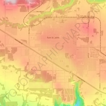
Nome: Mappa topografica Fort St. John, altitudine, rilievo.
Altitudine media: 676 m
Altitudine minima: 493 m
Altitudine massima: 780 m
Fai una donazione
Equipaggiati per la tua prossima avventura:
In qualità di Affiliato Amazon, questo sito riceve una commissione sugli acquisti idonei, senza costi aggiuntivi per l’utente.
Altre mappe topografiche
Clicca su una mappa per visualizzarne la topografia, l'altitudine e il rilievo.
Pine River
Canada > British Columbia > Peace River Regional District > Area E (Moberly Lake/Sukunka Valley)
Altitudine media: 973 m
Parkland
Canada > British Columbia > Peace River Regional District > Area D (Kiskatinaw Valley)
Altitudine media: 726 m
Jack Lake
Canada > British Columbia > Peace River Regional District > Area B (Finlay Valley/Beatton Valley)
Altitudine media: 996 m
Crescent Park
Canada > British Columbia > Peace River Regional District > Dawson Creek
Altitudine media: 687 m
Fai una donazione
Equipaggiati per la tua prossima avventura:
In qualità di Affiliato Amazon, questo sito riceve una commissione sugli acquisti idonei, senza costi aggiuntivi per l’utente.
Milligan Hills
Canada > British Columbia > Peace River Regional District > Area B (Finlay Valley/Beatton Valley)
Altitudine media: 891 m
Carbon Peak
Canada > British Columbia > Peace River Regional District > Area E (Moberly Lake/Sukunka Valley)
Altitudine media: 1’421 m
Attachie
Canada > British Columbia > Peace River Regional District > Area B (Finlay Valley/Beatton Valley)
Altitudine media: 477 m
Rocky Mountains
Canada > British Columbia > Peace River Regional District > Area D (Kiskatinaw Valley)
Altitudine media: 1’458 m
Fai una donazione
Equipaggiati per la tua prossima avventura:
In qualità di Affiliato Amazon, questo sito riceve una commissione sugli acquisti idonei, senza costi aggiuntivi per l’utente.
Groundbirch
Canada > British Columbia > Peace River Regional District > Area E (Moberly Lake/Sukunka Valley)
Altitudine media: 741 m
Obo Lake
Canada > British Columbia > Peace River Regional District > Area B (Finlay Valley/Beatton Valley)
Altitudine media: 1’300 m
Fort St. John
Canada > British Columbia > Peace River Regional District > Fort St. John
Altitudine media: 650 m
Montney
Canada > British Columbia > Peace River Regional District > Area B (Finlay Valley/Beatton Valley)
It lies at an elevation of 700 meters (2,300 ft), along the BC Rail tracks.
Altitudine media: 718 m
Fai una donazione
Equipaggiati per la tua prossima avventura:
In qualità di Affiliato Amazon, questo sito riceve una commissione sugli acquisti idonei, senza costi aggiuntivi per l’utente.
Mount Russel
Canada > British Columbia > Peace River Regional District > Area B (Finlay Valley/Beatton Valley)
Altitudine media: 1’651 m
Windfall Lake
Canada > British Columbia > Peace River Regional District > Area E (Moberly Lake/Sukunka Valley)
Altitudine media: 1’655 m
Buckinghorse River
Canada > British Columbia > Peace River Regional District > Area B (Finlay Valley/Beatton Valley)
Altitudine media: 945 m
Beaver Lake
Canada > British Columbia > Peace River Regional District > Area E (Moberly Lake/Sukunka Valley)
Altitudine media: 692 m
Fai una donazione
Equipaggiati per la tua prossima avventura:
In qualità di Affiliato Amazon, questo sito riceve una commissione sugli acquisti idonei, senza costi aggiuntivi per l’utente.
Mount Ulysses
Canada > British Columbia > Peace River Regional District > Area B (Finlay Valley/Beatton Valley)
Altitudine media: 2’355 m
Pine Valley
Canada > British Columbia > Peace River Regional District > Area D (Kiskatinaw Valley)
Altitudine media: 766 m
Milligan Hills Provincial Park
Canada > British Columbia > Peace River Regional District > Area B (Finlay Valley/Beatton Valley)
Altitudine media: 875 m
Martin Falls
Canada > British Columbia > Peace River Regional District > Area E (Moberly Lake/Sukunka Valley)
Altitudine media: 763 m
Fai una donazione
Equipaggiati per la tua prossima avventura:
In qualità di Affiliato Amazon, questo sito riceve una commissione sugli acquisti idonei, senza costi aggiuntivi per l’utente.
Charlie Lake
Canada > British Columbia > Peace River Regional District > Area B (Finlay Valley/Beatton Valley)
Altitudine media: 761 m
Indian Head
Canada > British Columbia > Peace River Regional District > Area E (Moberly Lake/Sukunka Valley)
Altitudine media: 1’101 m
Omineca Mountains
Canada > British Columbia > Peace River Regional District > Area B (Finlay Valley/Beatton Valley)
Altitudine media: 1’010 m
Cassiar Mountains
Canada > British Columbia > Peace River Regional District > Area B (Finlay Valley/Beatton Valley)
Altitudine media: 935 m
Fai una donazione
Equipaggiati per la tua prossima avventura:
In qualità di Affiliato Amazon, questo sito riceve una commissione sugli acquisti idonei, senza costi aggiuntivi per l’utente.
Mount Jarvis
Canada > British Columbia > Peace River Regional District > Area D (Kiskatinaw Valley)
Altitudine media: 1’777 m
Rocky Mountains
Canada > British Columbia > Peace River Regional District > Area B (Finlay Valley/Beatton Valley)
Altitudine media: 1’019 m
Clayhurst
Canada > British Columbia > Peace River Regional District > Area B (Finlay Valley/Beatton Valley)
Altitudine media: 644 m
East Pine
Canada > British Columbia > Peace River Regional District > Area E (Moberly Lake/Sukunka Valley)
Altitudine media: 664 m
Fai una donazione
Equipaggiati per la tua prossima avventura:
In qualità di Affiliato Amazon, questo sito riceve una commissione sugli acquisti idonei, senza costi aggiuntivi per l’utente.
Buckinghorse River
Canada > British Columbia > Peace River Regional District > Area B (Finlay Valley/Beatton Valley)
Altitudine media: 1’200 m
Rocky Mountains
Canada > British Columbia > Peace River Regional District > Area B (Finlay Valley/Beatton Valley)
Altitudine media: 1’221 m
Rocky Mountains
Canada > British Columbia > Peace River Regional District > Area B (Finlay Valley/Beatton Valley)
Altitudine media: 870 m
Rocky Mountains
Canada > British Columbia > Peace River Regional District > Area B (Finlay Valley/Beatton Valley)
Altitudine media: 1’221 m
Fai una donazione
Equipaggiati per la tua prossima avventura:
In qualità di Affiliato Amazon, questo sito riceve una commissione sugli acquisti idonei, senza costi aggiuntivi per l’utente.
Site C Dam
Canada > British Columbia > Peace River Regional District > Area E (Moberly Lake/Sukunka Valley)
Altitudine media: 483 m
Rocky Mountains
Canada > British Columbia > Peace River Regional District > Area B (Finlay Valley/Beatton Valley)
Altitudine media: 986 m
Rocky Mountains
Canada > British Columbia > Peace River Regional District > Area E (Moberly Lake/Sukunka Valley)
Altitudine media: 1’462 m
Horsetail Falls
Canada > British Columbia > Peace River Regional District > Area E (Moberly Lake/Sukunka Valley)
Altitudine media: 1’024 m
Fai una donazione
Equipaggiati per la tua prossima avventura:
In qualità di Affiliato Amazon, questo sito riceve una commissione sugli acquisti idonei, senza costi aggiuntivi per l’utente.
Brandon Peak
Canada > British Columbia > Peace River Regional District > Area B (Finlay Valley/Beatton Valley)
Altitudine media: 1’801 m
Rocky Mountains
Canada > British Columbia > Peace River Regional District > Area D (Kiskatinaw Valley)
Altitudine media: 1’252 m
Rocky Mountains
Canada > British Columbia > Peace River Regional District > Area E (Moberly Lake/Sukunka Valley)
Altitudine media: 1’462 m