
Fai una donazione
Equipaggiati per la tua prossima avventura:
In qualità di Affiliato Amazon, questo sito riceve una commissione sugli acquisti idonei, senza costi aggiuntivi per l’utente.
Mappa topografica Labersricht
Clicca sulla mappa per visualizzare l'altitudine.
Fai una donazione
Equipaggiati per la tua prossima avventura:
In qualità di Affiliato Amazon, questo sito riceve una commissione sugli acquisti idonei, senza costi aggiuntivi per l’utente.
Labersricht
Altenhof | Auhof | Autobahnmeisterei Neumarkt i.d.OPf. | Beckenmühle | Blomenhof | Bodenhof | Bodenmühle | Eichenmühle | Frickenhofen | Friedlmühle | Fuchsberg | Großwiesenhof | Guglhof | Habersmühle | Helena | Höhenberg | Höhenberg im Tal | Holzheim | Iberlsmühle | Ischhofen | Karhof | Kohlenbrunnermühle | Koppenmühle | Labersricht | Lähr | Lampertshofen | Lippertshofen | Neumarkt in der Oberpfalz | Ottosau | Pelchenhofen | Pölling | Rittershof | Rödelberg | Schafhof | Schleifmühle | Schmermühle | Schönmühle | Stauf | Steinberg | Tiefenbrunn | Ungenricht | Voggenthal | Woffenbach | Wolfstein | Wolfstein
Fai una donazione
Equipaggiati per la tua prossima avventura:
In qualità di Affiliato Amazon, questo sito riceve una commissione sugli acquisti idonei, senza costi aggiuntivi per l’utente.
A proposito di questa mappa
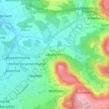
Nome: Mappa topografica Labersricht, altitudine, rilievo.
Altitudine media: 460 m
Altitudine minima: 405 m
Altitudine massima: 598 m
Fai una donazione
Equipaggiati per la tua prossima avventura:
In qualità di Affiliato Amazon, questo sito riceve una commissione sugli acquisti idonei, senza costi aggiuntivi per l’utente.
Altre mappe topografiche
Clicca su una mappa per visualizzarne la topografia, l'altitudine e il rilievo.
92318
Deutschland > Bayern > Landkreis Neumarkt in der Oberpfalz > Neumarkt in der Oberpfalz > Höhenberg im Tal
Altitudine media: 513 m