
Mappa topografica Jammu and Kashmir
Mappa interattiva
Clicca sulla mappa per visualizzare l'altitudine.
A proposito di questa mappa
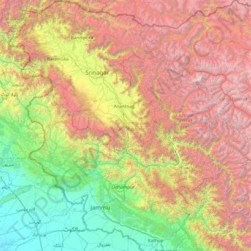
Nome: Mappa topografica Jammu and Kashmir, altitudine, rilievo.
Luogo: Jammu and Kashmir, India (32.27636 73.75003 34.78714 76.78032)
Altitudine media: 2’430 m
Altitudine minima: 208 m
Altitudine massima: 7’015 m
Jammu and Kashmir is home to several valleys such as the Kashmir Valley, Tawi Valley, Chenab Valley, Poonch Valley, Sind Valley, and Lidder Valley. The Kashmir valley is 100 km (62 mi) wide and 15,520.3 km2 (5,992.4 sq mi) in area. The Himalayas divide the Kashmir valley from the Tibetan plateau while the Pir Panjal range, which encloses the valley from the west and the south, separates it from the Punjab Plain of the Indo-Gangetic Plain. Along the northeastern flank of the Valley runs the main range of the Himalayas. This valley has an average height of 1,850 metres (6,070 ft) above sea-level, but the surrounding Pir Panjal range has an average elevation of 10,000 feet (3,000 m). The Jhelum River is the major Himalayan river which flows through the Kashmir valley. The southern Jammu region is mostly mountainous, with the Shivaliks, the middle and the great Himalayas running parallel to each other in a southeast-northwest direction. A narrow southwestern strip constitutes fertile plains. The Chenab, Tawi and Ravi are important rivers flowing through the Jammu region.
Altre mappe topografiche
Clicca su una mappa per visualizzarne la topografia, l'altitudine e il rilievo.
Bengaluru
India > Karnataka > Bangalore North
Bengaluru, Bangalore North, Bengaluru Urban District, Karnataka, India
Altitudine media: 881 m
Chennai
India > Tamil Nadu > Chennai
Chennai, Chennai District, Tamil Nadu, India
Altitudine media: 8 m
3d
India > Rajasthan > Ganganagar Tehsil > 1 LNP
3d, 1 LNP, Ganganagar Tehsil, Sri Ganganagar District, Rajasthan, India
Altitudine media: 178 m
Bachupally mandal
Bachupally mandal, Medchal–Malkajgiri District, Telangana, 500090, India
Altitudine media: 593 m
Pune
India > Maharashtra > Pune City > Pune
Pune, Pune City, Pune District, Maharashtra, 411001, India
Altitudine media: 641 m
Kolkata
Kolkata, Kolkata District, West Bengal, 700073, India
Altitudine media: 5 m
Vijayawada
India > Andhra Pradesh > Vijayawada (Urban)
Vijayawada, Vijayawada (Urban), NTR District, Andhra Pradesh, 520001, India
Altitudine media: 36 m
Lucknow
India > Uttar Pradesh > Lucknow
Lucknow, Lucknow District, Uttar Pradesh, 226027, India
Altitudine media: 120 m
Sultanpur Lodhi
India > Punjab > Sultanpur Lodhi Tahsil
Sultanpur Lodhi, Sultanpur Lodhi Tahsil, Kapurthala District, Punjab, 144626, India
Altitudine media: 214 m
Banjar
India > Himachal Pradesh > Bhuntar
Banjar, Bhuntar, Kullu District, Himachal Pradesh, 175125, India
Altitudine media: 1’271 m
Pallapalayam - Kannampalayam Canal
India > Tamil Nadu > Sulur > Kannampalayam
Pallapalayam - Kannampalayam Canal, Papampatti Pirivu, Kannampalayam, Sulur, Coimbatore District, Tamil Nadu, 641402, India
Altitudine media: 381 m
Kannampalayam
India > Tamil Nadu > Mathavaram
Kannampalayam, Mathavaram, Thiruvallur District, Tamil Nadu, 600066, India
Altitudine media: 7 m
Tharangambadi
Tharangambadi, Mayiladuthurai District, Tamil Nadu, India
Altitudine media: 5 m
North Sentinel Island
India > Andaman and Nicobar Islands > Ferrargunj
North Sentinel Island, Ferrargunj, South Andaman District, Andaman and Nicobar Islands, India
Altitudine media: 20 m
Gurgaon
India > Haryana > Gurugram District
Gurgaon, Gurugram District, Haryana, India
Altitudine media: 237 m
Prayagraj
India > Uttar Pradesh > Prayagraj
Prayagraj, Prayagraj District, Uttar Pradesh, 211001, India
Altitudine media: 91 m
Coimbatore
India > Tamil Nadu > Coimbatore North
Coimbatore, Coimbatore North, Coimbatore District, Tamil Nadu, 641001, India
Altitudine media: 452 m
Akpa
India > Himachal Pradesh > Moorang
Akpa, Moorang, Kinnaur District, Himachal Pradesh, 172116, India
Altitudine media: 2’709 m
Mysuru
India > Karnataka > Mysuru taluk
Mysuru, Mysuru taluk, Mysuru District, Karnataka, 570001, India
Altitudine media: 727 m
Kottakombur
Kottakombur, Devikulam, Idukki District, Kerala, India
Altitudine media: 1’919 m
Thiruvananthapuram
India > Kerala > Thiruvananthapuram
Thiruvananthapuram, Thiruvananthapuram District, Kerala, 695001, India
Altitudine media: 33 m