
Mappa topografica Ball Ground
Mappa interattiva
Clicca sulla mappa per visualizzare l'altitudine.
A proposito di questa mappa
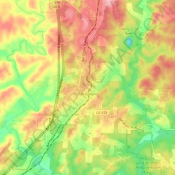
Nome: Mappa topografica Ball Ground, altitudine, rilievo.
Luogo: Ball Ground, Cherokee County, Georgia, United States (34.31118 -84.41254 34.37075 -84.32178)
Altitudine media: 331 m
Altitudine minima: 243 m
Altitudine massima: 414 m
According to the United States Census Bureau as of 2020, Ball Ground has a total area of 6.3 sq mi (16 km2), of which 0.04 sq mi (0.10 km2), or 0.63%, is water. The city's elevation averages around 1,100 ft (340 m) above sea level, ranging from just over 1,000 ft (300 m) in the valleys to around 1,200 ft (370 m) on several hilltops within the city. Unlike most other parts of Cherokee County, Ball Ground is not in a floodplain and has no typically flood prone areas. To protect the water and surrounding lands, the city government has ordinances in place for stream buffer protection, watershed protection, and wetland protection.
Altre mappe topografiche
Clicca su una mappa per visualizzarne la topografia, l'altitudine e il rilievo.
Canton
United States > Georgia > Cherokee County
Canton, Cherokee County, Georgia, United States
Altitudine media: 320 m
Woodstock
United States > Georgia > Cherokee County
Woodstock, Cherokee County, Georgia, United States
Altitudine media: 296 m
Worley Crossroads
United States > Georgia > Cherokee County
Worley Crossroads, Cherokee County, Georgia, United States
Altitudine media: 378 m
Bear Mountain
United States > Georgia > Cherokee County
Bear Mountain, Cherokee County, Georgia, United States
Altitudine media: 497 m
Hickory Flat
United States > Georgia > Cherokee County
Hickory Flat, Cherokee County, Georgia, 30115, United States
Altitudine media: 307 m
Burris Crossroads
United States > Georgia > Cherokee County
Burris Crossroads, Cherokee County, Georgia, United States
Altitudine media: 386 m
Waleska
United States > Georgia > Cherokee County
Waleska, Cherokee County, Georgia, United States
Altitudine media: 335 m
Ophir
United States > Georgia > Cherokee County
Ophir, Cherokee County, Georgia, United States
Altitudine media: 341 m
Ball Ground
United States > Georgia > Cherokee County > Ball Ground
Ball Ground, Cherokee County, Georgia, 30107, United States
Altitudine media: 332 m
Holly Springs
United States > Georgia > Cherokee County
Holly Springs, Cherokee County, Georgia, United States
Altitudine media: 306 m
Beck Lake
United States > Georgia > Cherokee County
Beck Lake, Cherokee County, Georgia, United States
Altitudine media: 341 m
Free Home
United States > Georgia > Cherokee County
Free Home, Cherokee County, Georgia, 30155, United States
Altitudine media: 360 m