
Mappa topografica Ball Ground
Mappa interattiva
Clicca sulla mappa per visualizzare l'altitudine.
Ball Ground
According to the United States Census Bureau, the city has a total area of 5.8 square miles (15.1 km2), of which 0.031 square miles (0.08 km2), or 0.50%, is water. The city's elevation averages around 1,100 feet (340 m) above sea level, ranging from just over 1,000 feet (300 m) in the valleys to around 1,200 feet (370 m) on several hilltops within the city.
A proposito di questa mappa
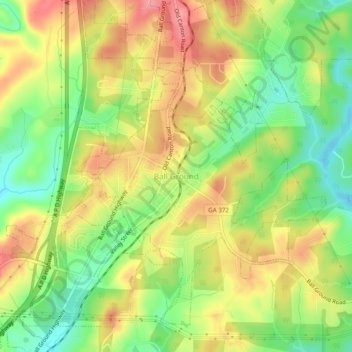
Nome: Mappa topografica Ball Ground, altitudine, rilievo.
Luogo: Ball Ground, Cherokee County, Georgia, 30107, United States (34.31823 -84.39657 34.35823 -84.35657)
Altitudine media: 332 m
Altitudine minima: 281 m
Altitudine massima: 383 m