Geolocalizza

Mappa topografica Lyndhurst

Mappa interattiva

Clicca sulla mappa per visualizzare l'altitudine.

A proposito di questa mappa

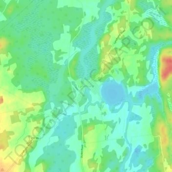
Nome: Mappa topografica Lyndhurst, altitudine, rilievo.

Luogo: Lyndhurst, Leeds and the Thousand Islands, Leeds and Grenville Counties, Eastern Ontario, Ontario, K0E 1N0, Canada (44.52991 -76.14515 44.56991 -76.10515)

Altitudine media: 98 m

Altitudine minima: 81 m

Altitudine massima: 130 m

Altre mappe topografiche

Clicca su una mappa per visualizzarne la topografia, l'altitudine e il rilievo.

Lansdowne

Canada > Ontario > Leeds and Grenville Counties > Leeds and the Thousand Islands

Lansdowne, Leeds and the Thousand Islands, Leeds and Grenville Counties, Eastern Ontario, Ontario, K0E 1L0, Canada

Altitudine media: 101 m

Seeleys Bay

Canada > Ontario > Leeds and Grenville Counties > Leeds and the Thousand Islands > Seeley's Bay

Seeleys Bay, Seeley's Bay, Leeds and the Thousand Islands, Leeds and Grenville Counties, Eastern Ontario, Ontario, K0H 2N0, Canada

Altitudine media: 105 m

Leeds

Canada > Ontario > Leeds and Grenville Counties > Leeds and the Thousand Islands

Leeds, Leeds and the Thousand Islands, Leeds and Grenville Counties, Eastern Ontario, Ontario, Canada

Altitudine media: 104 m

Seeley's Bay

Canada > Ontario > Leeds and Grenville Counties > Leeds and the Thousand Islands > Seeley's Bay

Seeley's Bay, Leeds and the Thousand Islands, Leeds and Grenville Counties, Eastern Ontario, Ontario, K0H 2N0, Canada

Altitudine media: 106 m

Blue Mountain

Canada > Ontario > Leeds and Grenville Counties > Leeds and the Thousand Islands

Blue Mountain, Leeds and the Thousand Islands, Leeds and Grenville Counties, Eastern Ontario, Ontario, Canada

Altitudine media: 124 m

Waterton

Canada > Ontario > Leeds and Grenville Counties > Leeds and the Thousand Islands > Waterton

Waterton, Leeds and the Thousand Islands, Leeds and Grenville Counties, Eastern Ontario, Ontario, Canada

Altitudine media: 97 m