
Mappa topografica Leeds
Clicca sulla mappa per visualizzare l'altitudine.
A proposito di questa mappa
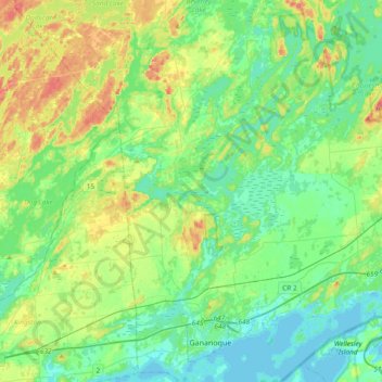
Nome: Mappa topografica Leeds, altitudine, rilievo.
Altitudine media: 104 m
Altitudine minima: 73 m
Altitudine massima: 185 m
Altre mappe topografiche
Clicca su una mappa per visualizzarne la topografia, l'altitudine e il rilievo.
Seeleys Bay
Canada > Ontario > Leeds and Grenville Counties > Leeds and the Thousand Islands > Seeley's Bay
Altitudine media: 105 m
Waterton
Canada > Ontario > Leeds and Grenville Counties > Leeds and the Thousand Islands > Waterton
Altitudine media: 97 m
Lansdowne
Canada > Ontario > Leeds and Grenville Counties > Leeds and the Thousand Islands
Altitudine media: 101 m
Junetown
Canada > Ontario > Leeds and Grenville Counties > Leeds and the Thousand Islands
Altitudine media: 110 m
Lyndhurst
Canada > Ontario > Leeds and Grenville Counties > Leeds and the Thousand Islands
Altitudine media: 98 m
Seeley's Bay
Canada > Ontario > Leeds and Grenville Counties > Leeds and the Thousand Islands
Altitudine media: 106 m
Outlet
Canada > Ontario > Leeds and Grenville Counties > Leeds and the Thousand Islands
Altitudine media: 97 m
Quabbin
Canada > Ontario > Leeds and Grenville Counties > Leeds and the Thousand Islands
Altitudine media: 97 m
Rochester Bay
Canada > Ontario > Leeds and Grenville Counties > Leeds and the Thousand Islands
Altitudine media: 74 m
Codfish Island
Canada > Ontario > Leeds and Grenville Counties > Leeds and the Thousand Islands
Altitudine media: 79 m
Why Island
Canada > Ontario > Leeds and Grenville Counties > Leeds and the Thousand Islands
Altitudine media: 92 m
Seeleys Bay
Canada > Ontario > Leeds and Grenville Counties > Leeds and the Thousand Islands > Seeley's Bay
Altitudine media: 105 m
Outlet
Canada > Ontario > Leeds and Grenville Counties > Leeds and the Thousand Islands
Altitudine media: 97 m