Fai una donazione
Equipaggiati per la tua prossima avventura:
In qualità di Affiliato Amazon, questo sito riceve una commissione sugli acquisti idonei, senza costi aggiuntivi per l’utente.
Mappa topografica Haryana
Clicca sulla mappa per visualizzare l'altitudine.
Fai una donazione
Equipaggiati per la tua prossima avventura:
In qualità di Affiliato Amazon, questo sito riceve una commissione sugli acquisti idonei, senza costi aggiuntivi per l’utente.
Haryana
Haryana is a landlocked state in northern India. It is between 27°39' to 30°35' N latitude and between 74°28' and 77°36' E longitude. The total geographical area of the state is 4.42 m ha, which is 1.4% of the geographical area of the country. The altitude of Haryana varies between 700 and 3600 ft (200 metres to 1200 metres) above sea level. Haryana has only 4% (compared with national 21.85%) area under forests. Karoh Peak, a 1,467-metre (4,813 ft) tall mountain peak in the Sivalik Hills range of the greater Himalayas range located near Morni Hills area of Panchkula district, is highest point in Haryana. Most of the state sits atop the fertile Punjab Plain, a subsection of the Indo-Gangetic Plain. Haryana has 4 states and 2 union territories on its border – Punjab, Rajasthan, Uttar Pradesh, Himachal Pradesh, Delhi, and Chandigarh.
Fai una donazione
Equipaggiati per la tua prossima avventura:
In qualità di Affiliato Amazon, questo sito riceve una commissione sugli acquisti idonei, senza costi aggiuntivi per l’utente.
A proposito di questa mappa
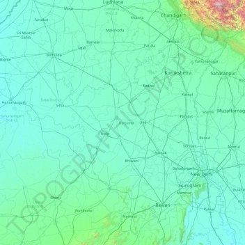
Nome: Mappa topografica Haryana, altitudine, rilievo.
Luogo: Haryana, India (27.65263 74.47351 30.92877 77.60214)
Altitudine media: 281 m
Altitudine minima: 169 m
Altitudine massima: 3’601 m
Fai una donazione
Equipaggiati per la tua prossima avventura:
In qualità di Affiliato Amazon, questo sito riceve una commissione sugli acquisti idonei, senza costi aggiuntivi per l’utente.
Altre mappe topografiche
Clicca su una mappa per visualizzarne la topografia, l'altitudine e il rilievo.
Maharashtra
Maharashtra is the third largest state by area in India. The Western Ghats better known as Sahyadri, are a hilly range running parallel to the coast, at an average elevation of 1,200 metres (4,000 ft). Kalsubai, a peak in the Sahyadris, near Nashik city is the highest elevated point in Maharashtra. To the west…
Altitudine media: 478 m
Kunigal
India > Karnataka > Kunigal taluk
Kunigal is located at 13°01′N 77°02′E / 13.02°N 77.03°E / 13.02; 77.03. It has an average elevation of 773 metres (2536 feet). It is situated on the National Highway 75 (India) connecting Bengaluru and Mangaluru and State Highway 33 (Karnataka) connecting Tumakuru and Madduru. Kunigal is…
Altitudine media: 775 m
Fai una donazione
Equipaggiati per la tua prossima avventura:
In qualità di Affiliato Amazon, questo sito riceve una commissione sugli acquisti idonei, senza costi aggiuntivi per l’utente.
Guwahati
Professor Abani Kumar Bhagawati of Gauhati University stated that since before there were sufficient wetlands to absorb rainwater and channels to carry excess water to the Brahmaputra, the city did not experience floods. However, human interference has disrupted the natural topography, leading to the current…
Altitudine media: 113 m
Western Ghats
The range starts near south of the Tapti river and runs approximately 1,600 km (990 mi) through the states of Gujarat, Maharashtra, Karnataka, Goa, Kerala and Tamil Nadu ending at Marunthuvazh Malai, Swamithope near the southern tip of India. These hills cover 160,000 km2 (62,000 sq mi) and form the catchment…
Altitudine media: 2’225 m
Solapur
India > Maharashtra > Solapur North
Solapur is located at 17°41′N 75°55′E / 17.68°N 75.92°E / 17.68; 75.92. It has an average elevation of 458 metres (1502 feet). It is bordered by Ahmednagar district on the north; Osmanabad district on the north and northeast.
Altitudine media: 469 m
Fai una donazione
Equipaggiati per la tua prossima avventura:
In qualità di Affiliato Amazon, questo sito riceve una commissione sugli acquisti idonei, senza costi aggiuntivi per l’utente.
Fai una donazione
Equipaggiati per la tua prossima avventura:
In qualità di Affiliato Amazon, questo sito riceve una commissione sugli acquisti idonei, senza costi aggiuntivi per l’utente.
Thiruvananthapuram
India > Kerala > Thiruvananthapuram
Thiruvananthapuram is built on seven hills by the seashore and is at 8°30′N 76°54′E / 8.5°N 76.9°E / 8.5; 76.9 on the west coast, near the southern tip of mainland India. The city is on the west coast of India and is bounded by the Laccadive Sea to its west and the Western Ghats to its east.…
Altitudine media: 33 m
Alibag
India > Maharashtra > Alibag Taluka
Alibag is located about 120 km south of Mumbai, at 18°38′29″N 72°52′20″E / 18.64139°N 72.87222°E / 18.64139; 72.87222. The average elevation is 0 metres (0 feet).The District Government offices are located along the sea coast road. Alibag is the center place of Raigad District.
Altitudine media: 12 m
Madurai
India > Tamil Nadu > Madurai
Madurai is located at 9°56′N 78°07′E / 9.93°N 78.12°E / 9.93; 78.12. It has an average elevation of 101 metres. The city of Madurai lies on the flat and fertile plain of the river Vaigai, which runs in the northwest-southeast direction through the city, dividing it into two almost equal…
Altitudine media: 138 m
Fai una donazione
Equipaggiati per la tua prossima avventura:
In qualità di Affiliato Amazon, questo sito riceve una commissione sugli acquisti idonei, senza costi aggiuntivi per l’utente.
Salem
Salem is located at 11°40′N 78°08′E / 11.67°N 78.14°E / 11.67; 78.14, at an average elevation of 278 m (912 ft). The city is surrounded by hills: Nagaramalai on the north, Jarugumalai on the south, Kanjamalai on the west, Godumalai on the east and the Shevaroy Hills on the northeast.…
Altitudine media: 418 m
Chennai
Chennai is located on the south–eastern coast of India in the north–eastern part of Tamil Nadu on a flat coastal plain known as the Eastern Coastal Plains. Its average elevation is around 6.7 metres (22 ft), and its highest point is 60 m (200 ft). Chennai is 2,184 kilometres (1,357 mi) south of Delhi,…
Altitudine media: 7 m
Fai una donazione
Equipaggiati per la tua prossima avventura:
In qualità di Affiliato Amazon, questo sito riceve una commissione sugli acquisti idonei, senza costi aggiuntivi per l’utente.
Ranchi
Ranchi lies at 23°22′N 85°20′E / 23.36°N 85.33°E / 23.36; 85.33 near to the Tropic of Cancer. The city covers an area of 175 km2 (68 sq mi) and its average elevation is 651 m above sea level. Ranchi is located in the southern part of the Chota Nagpur plateau, which is the eastern section of…
Altitudine media: 648 m
Mumbai
Mumbai lies at the mouth of the Ulhas River on the western coast of India, in the coastal region known as the Konkan. It sits on Salsette Island (Sashti Island), which it partially shares with the Thane district. Mumbai is bounded by the Arabian Sea to the west. Many parts of the city lie just above sea level,…
Altitudine media: 13 m
Fai una donazione
Equipaggiati per la tua prossima avventura:
In qualità di Affiliato Amazon, questo sito riceve una commissione sugli acquisti idonei, senza costi aggiuntivi per l’utente.
Mangaluru
India > Karnataka > Mangaluru taluk
Mangalore is also the administrative headquarters of the Dakshina Kannada district; it is a commercial, industrial, educational, healthcare, and startup hub. The city's international airport is the second-largest and second-busiest airport in Karnataka. Mangalore City Corporation is responsible for the civic…
Altitudine media: 25 m
Navi Mumbai
India > Maharashtra > Thane > Navi Mumbai
Navi Mumbai (Marathi pronunciation: , also known by its former name New Bombay), is a planned city off the west coast of the Indian state of Maharashtra in Konkan division. The city is divided into two parts, North Navi Mumbai and South Navi Mumbai, for the individual development of Panvel Mega City, which…
Altitudine media: 30 m
Pithoragarh
India > Uttarakhand > Pithoragarh Tehsil
Pithoragarh is located at 29°35′N 80°13′E / 29.58°N 80.22°E / 29.58; 80.22. in the district of Pithoragarh, Uttarakhand, India. It lies in the revenue Division of Kumaon and is located 188 km northeast of Nainital, the administrative headquarters of Kumaon. It has an average elevation of 1,627…
Altitudine media: 1’617 m
Fai una donazione
Equipaggiati per la tua prossima avventura:
In qualità di Affiliato Amazon, questo sito riceve una commissione sugli acquisti idonei, senza costi aggiuntivi per l’utente.
Fai una donazione
Equipaggiati per la tua prossima avventura:
In qualità di Affiliato Amazon, questo sito riceve una commissione sugli acquisti idonei, senza costi aggiuntivi per l’utente.
Fai una donazione
Equipaggiati per la tua prossima avventura:
In qualità di Affiliato Amazon, questo sito riceve una commissione sugli acquisti idonei, senza costi aggiuntivi per l’utente.
Niphad
India > Maharashtra > Niphad Taluka
Niphad is the name both of the town and the Taluka headquartered there. It is within the Nashik District of Maharashtra, India. The Marathi name signifies "a place without mountains", and indeed the taluka's topography is fairly level, with hardly any hills. It is served by Niphad railway station. Niphad's…
Altitudine media: 550 m
Fai una donazione
Equipaggiati per la tua prossima avventura:
In qualità di Affiliato Amazon, questo sito riceve una commissione sugli acquisti idonei, senza costi aggiuntivi per l’utente.
Kargil
India > Ladakh > Kargil tehsil
Kargil has an average elevation of 2,676 metres (8,780 feet), and is situated along the banks of the Suru River (Indus). The town of Kargil is located 205 km (127 mi) from Srinagar, facing the Northern Areas across the LOC. Like other areas in the Himalayas, Kargil has a temperate climate. Summers are hot with…
Altitudine media: 3’262 m
Gwalior
India > Madhya Pradesh > Gird Tahsil
Gwalior is located at 26°13′N 78°11′E / 26.22°N 78.18°E / 26.22; 78.18. in northern Madhya Pradesh 300 km (186 miles) from Delhi. It has an average elevation of 197 metres (646 feet). Most part of it comes under the Bundelkhand area.
Altitudine media: 235 m
Kanpur
India > Uttar Pradesh > Kanpur
Situated in the flat Indo-Gangetic Plains, Kanpur has an average elevation of 318 metres (1,043 ft) above sea level. The Ganga flows by the city and several ghats are located on its banks, notably the Sati Chaura Ghat and Sarsaiya Ghat. The Brahmavart Ghat located at Bithoor (25 km northwards) is another ghat…
Altitudine media: 124 m
Fai una donazione
Equipaggiati per la tua prossima avventura:
In qualità di Affiliato Amazon, questo sito riceve una commissione sugli acquisti idonei, senza costi aggiuntivi per l’utente.
Vadodara
India > Gujarat > Vadodara Rural Taluka
Vadodara is located at 22°18′N 73°11′E / 22.30°N 73.19°E / 22.30; 73.19 in western India at an elevation of 39 metres (128 ft). It is the tenth-largest city in India with an area of 400 square kilometres (150 sq mi) and a population of 3.5 million, according to the 2010–11 census. The city…
Altitudine media: 36 m
Surat
India > Gujarat > Katargam Taluka > Surat
Surat is a port city situated on the banks of the Tapi river. Damming of the Tapi caused the original port facilities to close; the nearest port is now in the Magadalla and Hazira area of Surat Metropolitan Region.It has famous beach called 'Dumas Beach' located in Hazira. The city is located at 21°10′N…
Altitudine media: 11 m
Fai una donazione
Equipaggiati per la tua prossima avventura:
In qualità di Affiliato Amazon, questo sito riceve una commissione sugli acquisti idonei, senza costi aggiuntivi per l’utente.
Ranchi
Ranchi lies at 23°22′N 85°20′E / 23.36°N 85.33°E / 23.36; 85.33 near to the Tropic of Cancer. The city covers an area of 175 km2 (68 sq mi) and its average elevation is 651 m above sea level. Ranchi is located in the southern part of the Chota Nagpur plateau, which is the eastern section of…
Altitudine media: 648 m
Fai una donazione
Equipaggiati per la tua prossima avventura:
In qualità di Affiliato Amazon, questo sito riceve una commissione sugli acquisti idonei, senza costi aggiuntivi per l’utente.
Shimla
Shimla is on the south-western ranges of the Himalayas at 31°37′N 77°06′E / 31.61°N 77.10°E / 31.61; 77.10. It has an average altitude of 2,206 metres (7,238 ft) above mean sea level and extends along a ridge with seven spurs. The city stretches nearly 9.2 kilometres (5.7 mi) from east to west.
Altitudine media: 1’557 m
Pathanamthitta
Pathanamthitta has an average elevation of 18 metres (62 ft) above sea level.
Altitudine media: 63 m
Fai una donazione
Equipaggiati per la tua prossima avventura:
In qualità di Affiliato Amazon, questo sito riceve una commissione sugli acquisti idonei, senza costi aggiuntivi per l’utente.
Fai una donazione
Equipaggiati per la tua prossima avventura:
In qualità di Affiliato Amazon, questo sito riceve una commissione sugli acquisti idonei, senza costi aggiuntivi per l’utente.
Fai una donazione
Equipaggiati per la tua prossima avventura:
In qualità di Affiliato Amazon, questo sito riceve una commissione sugli acquisti idonei, senza costi aggiuntivi per l’utente.
Fai una donazione
Equipaggiati per la tua prossima avventura:
In qualità di Affiliato Amazon, questo sito riceve una commissione sugli acquisti idonei, senza costi aggiuntivi per l’utente.
Fai una donazione
Equipaggiati per la tua prossima avventura:
In qualità di Affiliato Amazon, questo sito riceve una commissione sugli acquisti idonei, senza costi aggiuntivi per l’utente.
Fai una donazione
Equipaggiati per la tua prossima avventura:
In qualità di Affiliato Amazon, questo sito riceve una commissione sugli acquisti idonei, senza costi aggiuntivi per l’utente.
Talegaon Dabhade
India > Maharashtra > Mawal
Talegaon Dabhade has an altitude of 672 meters from sea level (2200 Ft), and thus enjoys pleasant weather round the year. Situated on the laps of Sahyadri mountain ranges, during monsoon rains, Talegaon Dabhade witnesses heavy rainfall adding to its overall natural beauty. Indrayani River, which originates in…
Altitudine media: 616 m
Varanasi
India > Uttar Pradesh > Sadar
Varanasi is located at an elevation of 80.71 metres (264.8 ft) in the centre of the Ganges valley of North India, in the Eastern part of the state of Uttar Pradesh, along the left crescent-shaped bank of the Ganges, averaging between 15 metres (50 ft) and 21 metres (70 ft) above the river. The city is the…
Altitudine media: 77 m
Fai una donazione
Equipaggiati per la tua prossima avventura:
In qualità di Affiliato Amazon, questo sito riceve una commissione sugli acquisti idonei, senza costi aggiuntivi per l’utente.
Bhopal
India > Madhya Pradesh > Huzur Tahsil
Bhopal has an average elevation of 500 metres (1401 ft) and is located in the central part of India, just north of the upper limit of the Vindhya mountain ranges. Located on the Malwa plateau, it is higher than the north Indian plains and the land rises towards the Vindhya Range to the south. The city has…
Altitudine media: 498 m
Jaitaran
India > Rajasthan > Jaitaran Tehsil
Jaitaran is located at 26°12′N 73°56′E / 26.2°N 73.94°E / 26.2; 73.94. It has an average elevation of 307metres (1007feet).
Altitudine media: 300 m
Fai una donazione
Equipaggiati per la tua prossima avventura:
In qualità di Affiliato Amazon, questo sito riceve una commissione sugli acquisti idonei, senza costi aggiuntivi per l’utente.
Mahendragiri
India > Odisha > Ramagiri > Burakhat
Mahendragiri, is a mountain in Rayagada block of the district of Gajapati, Odisha, India. It is situated amongst the Eastern Ghats at an elevation of 1,501 metres (4,925 ft). The second highest motorable mountain of Odisha and 8th highest peak of Odisha.
Altitudine media: 1’108 m
Fai una donazione
Equipaggiati per la tua prossima avventura:
In qualità di Affiliato Amazon, questo sito riceve una commissione sugli acquisti idonei, senza costi aggiuntivi per l’utente.
Gundlupet
India > Karnataka > Gundlupet taluk
Gundlupet is located at 11°48′N 76°41′E / 11.8°N 76.68°E / 11.8; 76.68. It has an average elevation of 816 metres (2,677 feet).
Altitudine media: 807 m
Porbandar
India > Gujarat > Porbandar Taluka
Porbandar is located at 21°37′48″N 69°36′0″E / 21.63000°N 69.60000°E / 21.63000; 69.60000. It has an average elevation of 1 metre (3 ft).
Altitudine media: 18 m
Dahanu
India > Maharashtra > Dahanu Taluka
Dahanu is located at 19°58′N 72°44′E / 19.97°N 72.73°E / 19.97; 72.73. It has an average elevation of 9.89 metres. To the west of the town is the coast of the Arabian Sea while the east is lined with the Sahyadri ranges. This combination has made Dahanu a tourist destination. Sprawling Chickoo…
Altitudine media: 9 m
Fai una donazione
Equipaggiati per la tua prossima avventura:
In qualità di Affiliato Amazon, questo sito riceve una commissione sugli acquisti idonei, senza costi aggiuntivi per l’utente.
Tipaturu
India > Karnataka > Tipaturu taluk
Tiptur has been surrounded by from the west side Arsikere and channarayapatna. from the east side Chikkanayakana halli, Gubbi, Turuvekere. Tiptur is approximately 73 km (45 mi) west of Tumkur along National Highway 206 (now renumbered as National Highway 48). It is at a distance of 140 km (87 mi) northwest…
Altitudine media: 855 m
Fai una donazione
Equipaggiati per la tua prossima avventura:
In qualità di Affiliato Amazon, questo sito riceve una commissione sugli acquisti idonei, senza costi aggiuntivi per l’utente.
Fai una donazione
Equipaggiati per la tua prossima avventura:
In qualità di Affiliato Amazon, questo sito riceve una commissione sugli acquisti idonei, senza costi aggiuntivi per l’utente.
