
Mappa topografica Mount Jellore
Clicca sulla mappa per visualizzare l'altitudine.
A proposito di questa mappa
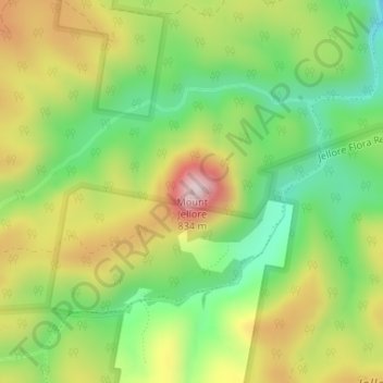
Nome: Mappa topografica Mount Jellore, altitudine, rilievo.
Luogo: Mount Jellore, New South Wales, Australia (-34.36960 150.37036 -34.36950 150.37046)
Altitudine media: 593 m
Altitudine minima: 416 m
Altitudine massima: 820 m
Altre mappe topografiche
Clicca su una mappa per visualizzarne la topografia, l'altitudine e il rilievo.
Sydney
Sydney's topography is characterized by a diverse landscape that seamlessly blends coastal features with inland plateaus. The city is divided into two primary regions: the relatively flat Cumberland Plain to the south and west of Sydney Harbour, and the elevated Hornsby Plateau to the north. The Cumberland…
Altitudine media: 53 m
Goulburn
Owing to its elevation, Goulburn has an oceanic climate (Cfb) with warm summers and cool winters; with a high diurnal range. Its climate is variable much of the year, though generally dry with maximum temperatures ranging from 11.8 °C (53.2 °F) in July to 28.3 °C (82.9 °F) in January. Rainfall is…
Altitudine media: 666 m
Orange
Orange is a city in the Central Tablelands region of New South Wales, Australia. It is 254 km (158 mi) west of the state capital, Sydney [206 km (128 mi) on a great circle], at an altitude of 862 metres (2,828 ft). Orange had an estimated urban population of 40,493 as of June 2018 making the city a significant…
Altitudine media: 852 m
Blue Mountains
A sandstone plateau dominated by a landscape of endless eucalyptus forests, the Blue Mountains are located at the top of a 470-million-year-old quartzite. In the Permian period, a shallow sea covered the region, when rivers brought shales, siltstones and mudstones. Then during the Mesozoic period, rivers…
Altitudine media: 566 m
Jamberoo
The valley of Jamberoo and the Minnamurra River is steep-sided and reasonably narrow. As a result, the town and valley is not subject to the extremes of weather that nearby Albion Park is. This is a significant observation because the climate data for the district is recorded at Albion Park. Local research…
Altitudine media: 207 m
Sugarloaf State Conservation Area
Australia > New South Wales > Newcastle-Maitland
Altitudine media: 94 m