
Fai una donazione
Equipaggiati per la tua prossima avventura:
In qualità di Affiliato Amazon, questo sito riceve una commissione sugli acquisti idonei, senza costi aggiuntivi per l’utente.
Mappa topografica Nedumpana
Clicca sulla mappa per visualizzare l'altitudine.
Fai una donazione
Equipaggiati per la tua prossima avventura:
In qualità di Affiliato Amazon, questo sito riceve una commissione sugli acquisti idonei, senza costi aggiuntivi per l’utente.
Nedumpana
Nedumpana is a countryside in Kollam district featuring a typical kerala village consisting paddy fields, wetlands, river channels and highlands. The area can be categorised into Ida Nadu (Mid land or plains) with an average elevation of 108 meter above mean sea level. Laterite soil and Alluvial Soil constitutes the major soil types. Major rainy season is the South West Monsoon, which bring about 130cm of rain. Out of the total area , 6276 acres of land is culturable.
Fai una donazione
Equipaggiati per la tua prossima avventura:
In qualità di Affiliato Amazon, questo sito riceve una commissione sugli acquisti idonei, senza costi aggiuntivi per l’utente.
A proposito di questa mappa
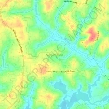
Nome: Mappa topografica Nedumpana, altitudine, rilievo.
Luogo: Nedumpana, Kollam, Kerala, 691580, India (8.88875 76.67450 8.92875 76.71450)
Altitudine media: 26 m
Altitudine minima: 1 m
Altitudine massima: 60 m
Fai una donazione
Equipaggiati per la tua prossima avventura:
In qualità di Affiliato Amazon, questo sito riceve una commissione sugli acquisti idonei, senza costi aggiuntivi per l’utente.