
Fai una donazione
Equipaggiati per la tua prossima avventura:
In qualità di Affiliato Amazon, questo sito riceve una commissione sugli acquisti idonei, senza costi aggiuntivi per l’utente.
Mappa topografica Waterford Township
Clicca sulla mappa per visualizzare l'altitudine.
Fai una donazione
Equipaggiati per la tua prossima avventura:
In qualità di Affiliato Amazon, questo sito riceve una commissione sugli acquisti idonei, senza costi aggiuntivi per l’utente.
Waterford Township
Like the rest of Southeast Michigan, Waterford Township has a continental climate. It has a higher elevation than Detroit (982 feet (299 m) compared to 585 feet (178 m)), and therefore the township is somewhat cooler than Detroit and other nearby cities. It is moderately cold in the winter with varied snowfall throughout. Spring varies from warm by day to cool at night. The township's warmest weather occurs in the summer with temperatures in the eighty to ninety degree range and typically high humidity. Summer is also the wettest season in the area. In recent years, Waterford Township has seen a few 100-plus-degree days. Fall starts warm, but November ends with high temperatures barely above freezing.
Fai una donazione
Equipaggiati per la tua prossima avventura:
In qualità di Affiliato Amazon, questo sito riceve una commissione sugli acquisti idonei, senza costi aggiuntivi per l’utente.
A proposito di questa mappa
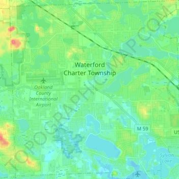
Nome: Mappa topografica Waterford Township, altitudine, rilievo.
Luogo: Waterford Township, Oakland County, Michigan, United States (42.61336 -83.44614 42.70592 -83.32540)
Altitudine media: 294 m
Altitudine minima: 279 m
Altitudine massima: 341 m
Fai una donazione
Equipaggiati per la tua prossima avventura:
In qualità di Affiliato Amazon, questo sito riceve una commissione sugli acquisti idonei, senza costi aggiuntivi per l’utente.
Altre mappe topografiche
Clicca su una mappa per visualizzarne la topografia, l'altitudine e il rilievo.
Fai una donazione
Equipaggiati per la tua prossima avventura:
In qualità di Affiliato Amazon, questo sito riceve una commissione sugli acquisti idonei, senza costi aggiuntivi per l’utente.
Jossman Acres
United States > Michigan > Oakland County > Springfield Charter Township
Altitudine media: 324 m
Fai una donazione
Equipaggiati per la tua prossima avventura:
In qualità di Affiliato Amazon, questo sito riceve una commissione sugli acquisti idonei, senza costi aggiuntivi per l’utente.
Union Lake
United States > Michigan > Oakland County > White Lake Charter Township
Altitudine media: 290 m
Carpenter Lake Nature Preserve
United States > Michigan > Oakland County > Southfield
Altitudine media: 207 m
Fai una donazione
Equipaggiati per la tua prossima avventura:
In qualità di Affiliato Amazon, questo sito riceve una commissione sugli acquisti idonei, senza costi aggiuntivi per l’utente.
Dollar Lake
United States > Michigan > Oakland County > Independence Charter Township
Altitudine media: 306 m
Cranberry Lake
United States > Michigan > Oakland County > White Lake Charter Township
Altitudine media: 295 m
Fai una donazione
Equipaggiati per la tua prossima avventura:
In qualità di Affiliato Amazon, questo sito riceve una commissione sugli acquisti idonei, senza costi aggiuntivi per l’utente.
Davisburg
United States > Michigan > Oakland County > Springfield Charter Township
Altitudine media: 309 m
Fai una donazione
Equipaggiati per la tua prossima avventura:
In qualità di Affiliato Amazon, questo sito riceve una commissione sugli acquisti idonei, senza costi aggiuntivi per l’utente.
Huron Heights
United States > Michigan > Oakland County > Waterford Charter Township
Altitudine media: 292 m
Rochester Hills
United States > Michigan > Oakland County > Rochester Hills
Rochester Hills is bordered to the north by Oakland Charter Township along Dutton Road, to the south by the city of Troy along South Boulevard, to the east by Shelby Township in Macomb County along Dequindre Road, and to the west by the city of Auburn Hills along part of Adams Road. Rochester Hills is also…
Altitudine media: 246 m