
Mappa topografica Rochester Hills
Clicca sulla mappa per visualizzare l'altitudine.
Rochester Hills
Rochester Hills is bordered to the north by Oakland Charter Township along Dutton Road, to the south by the city of Troy along South Boulevard, to the east by Shelby Township in Macomb County along Dequindre Road, and to the west by the city of Auburn Hills along part of Adams Road. Rochester Hills is also partially bordered by the city of Rochester to the east. Elevations in the city range from 690 feet (210 m) above sea level in the southeastern portion of the city to 1,010 feet (310 m) in the northwestern section.
A proposito di questa mappa
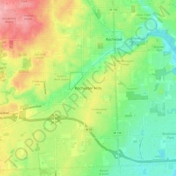
Nome: Mappa topografica Rochester Hills, altitudine, rilievo.
Altitudine media: 246 m
Altitudine minima: 204 m
Altitudine massima: 306 m