
Mappa topografica Roth
Clicca sulla mappa per visualizzare l'altitudine.
Roth
Bohnberg | Buch am Forst | Burgberg | Degendorf | Eichig | Friesenhof | Gnellenroth | Hammer | Heinach | Isling | Karolinenhöhe | Klosterlangheim | Kösten | Köttel | Krappenroth | Lahm | Mistelfeld | Mönchkröttendorf | Nassanger | Oberlangheim | Oberwallenstadt | Reundorf | Roth | Rothmannsthal | Schney | Schönsreuth | Seehof | Seubelsdorf | Stetten | Stöcken | Tiefenroth | Trieb | Unterwallenstadt | Weingarten
A proposito di questa mappa
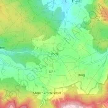
Nome: Mappa topografica Roth, altitudine, rilievo.
Altitudine media: 381 m
Altitudine minima: 296 m
Altitudine massima: 531 m