
Mappa topografica Vandiperiyar
Clicca sulla mappa per visualizzare l'altitudine.
Vandiperiyar
It is located at an altitude of 836 m above MSL.
A proposito di questa mappa
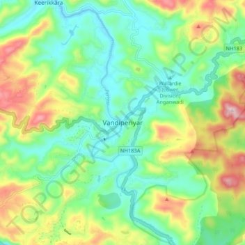
Nome: Mappa topografica Vandiperiyar, altitudine, rilievo.
Luogo: Vandiperiyar, Peerumade, Idukki, Kerala, 685533, India (9.53292 77.05189 9.61292 77.13189)
Altitudine media: 919 m
Altitudine minima: 782 m
Altitudine massima: 1’191 m
Altre mappe topografiche
Clicca su una mappa per visualizzarne la topografia, l'altitudine e il rilievo.
Periyar National Park Tiger Reserve
Periyar National Park lies in the middle of a mountainous area of the Cardamom Hills. In the north : The boundary commences from the point nearest to the Medaganam in the interstate boundary up to Vellimalai. and the east Thence the boundary follows the inter-state boundary from Vellimalai to Kallimalai Peak…
Altitudine media: 929 m