
Mappa topografica Frisby on the Wreake
Mappa interattiva
Clicca sulla mappa per visualizzare l'altitudine.
A proposito di questa mappa
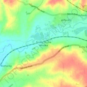
Nome: Mappa topografica Frisby on the Wreake, altitudine, rilievo.
Altitudine media: 83 m
Altitudine minima: 58 m
Altitudine massima: 117 m
Altre mappe topografiche
Clicca su una mappa per visualizzarne la topografia, l'altitudine e il rilievo.
Sproxton
United Kingdom > England > Leicestershire > Borough of Melton > Sproxton
Sproxton, Borough of Melton, Leicestershire, England, United Kingdom
Altitudine media: 137 m
Eye Kettleby
United Kingdom > England > Leicestershire > Borough of Melton > Melton Mowbray
Eye Kettleby, Melton Mowbray, Borough of Melton, Leicestershire, England, LE14 2TD, United Kingdom
Altitudine media: 95 m
Somerby
United Kingdom > England > Leicestershire > Borough of Melton
Somerby, Borough of Melton, Leicestershire, England, LE14 2QA, United Kingdom
Altitudine media: 169 m
Long Clawson
United Kingdom > England > Leicestershire > Borough of Melton
Long Clawson, Borough of Melton, Leicestershire, England, LE14 4NA, United Kingdom
Altitudine media: 78 m
Garthorpe
United Kingdom > England > Leicestershire > Borough of Melton
Garthorpe, Borough of Melton, Leicestershire, England, LE14 2SJ, United Kingdom
Altitudine media: 115 m
Buckminster
United Kingdom > England > Leicestershire > Borough of Melton
Buckminster, Borough of Melton, Leicestershire, England, NG33 5SB, United Kingdom
Altitudine media: 138 m