Geolocalizza

Mappa topografica Somerby

Mappa interattiva

Clicca sulla mappa per visualizzare l'altitudine.

A proposito di questa mappa

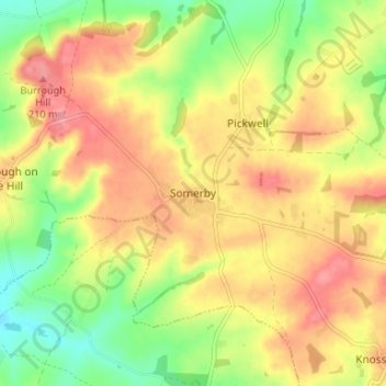
Nome: Mappa topografica Somerby, altitudine, rilievo.

Luogo: Somerby, Borough of Melton, Leicestershire, England, LE14 2QA, United Kingdom (52.66728 -0.86878 52.70728 -0.82878)

Altitudine media: 169 m

Altitudine minima: 120 m

Altitudine massima: 212 m

Altre mappe topografiche

Clicca su una mappa per visualizzarne la topografia, l'altitudine e il rilievo.

Sproxton

United Kingdom > England > Leicestershire > Borough of Melton > Sproxton

Sproxton, Borough of Melton, Leicestershire, England, United Kingdom

Altitudine media: 137 m

Eye Kettleby

United Kingdom > England > Leicestershire > Borough of Melton > Melton Mowbray

Eye Kettleby, Melton Mowbray, Borough of Melton, Leicestershire, England, LE14 2TD, United Kingdom

Altitudine media: 95 m

Long Clawson

United Kingdom > England > Leicestershire > Borough of Melton

Long Clawson, Borough of Melton, Leicestershire, England, LE14 4NA, United Kingdom

Altitudine media: 78 m

Garthorpe

United Kingdom > England > Leicestershire > Borough of Melton

Garthorpe, Borough of Melton, Leicestershire, England, LE14 2SJ, United Kingdom

Altitudine media: 115 m

Frisby on the Wreake

United Kingdom > England > Leicestershire > Borough of Melton

Frisby on the Wreake, Borough of Melton, Leicestershire, England, LE14 2NQ, United Kingdom

Altitudine media: 83 m

Buckminster

United Kingdom > England > Leicestershire > Borough of Melton

Buckminster, Borough of Melton, Leicestershire, England, NG33 5SB, United Kingdom

Altitudine media: 138 m