
Mappa topografica Crystal Beach
Clicca sulla mappa per visualizzare l'altitudine.
A proposito di questa mappa
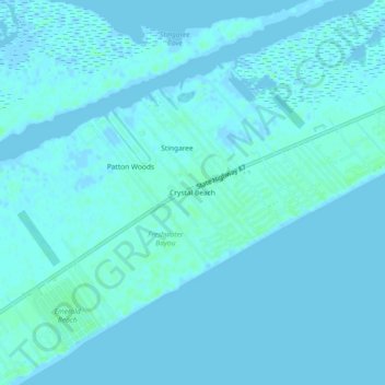
Nome: Mappa topografica Crystal Beach, altitudine, rilievo.
Luogo: Crystal Beach, Galveston County, Texas, 77600, United States (29.43726 -94.65891 29.47726 -94.61891)
Altitudine media: 1 m
Altitudine minima: -4 m
Altitudine massima: 7 m
Altre mappe topografiche
Clicca su una mappa per visualizzarne la topografia, l'altitudine e il rilievo.
Galveston
United States > Texas > Galveston County
On September 8, 1900, the island was struck by a devastating hurricane. This event holds the record as the United States' deadliest natural disaster. The city was devastated, and an estimated 6,000 to 8,000 people on the island were killed. Following the storm, a 10-mile (16 km) long, 17 foot (5.2 m) high…
Altitudine media: 1 m
Texas City
United States > Texas > Galveston County
Officially, the elevation of Texas City is 10 feet above sea level, though some areas are even lower. It was naturally vulnerable to flooding by hurricane storm surges and heavy rainstorms.
Altitudine media: 2 m
Texas City
United States > Texas > Galveston County
Officially, the elevation of Texas City is 10 feet above sea level, though some areas are even lower. It was naturally vulnerable to flooding by hurricane storm surges and heavy rainstorms.
Altitudine media: 2 m
Galveston
United States > Texas > Galveston County
On September 8, 1900, the island was struck by a devastating hurricane. This event holds the record as the United States' deadliest natural disaster. The city was devastated, and an estimated 6,000 to 8,000 people on the island were killed. Following the storm, a 10-mile (16 km) long, 17 foot (5.2 m) high…
Altitudine media: 1 m
Texas City
United States > Texas > Galveston County
Officially, the elevation of Texas City is 10 feet above mean sea level, though some areas are even lower. It was naturally vulnerable to flooding by hurricane storm surges and heavy rainstorms.
Altitudine media: 2 m
Galveston
United States > Texas > Galveston County
On September 8, 1900, the island was struck by a devastating hurricane. This event holds the record as the United States' deadliest natural disaster. The city was devastated, and an estimated 6,000 to 8,000 people on the island were killed. Following the storm, a 10-mile (16 km) long, 17 foot (5.2 m) high…
Altitudine media: 1 m
Galveston
United States > Texas > Galveston County
On September 8, 1900, the island was struck by a devastating hurricane. This event holds the record as the United States' deadliest natural disaster. The city was devastated, and an estimated 6,000 to 8,000 people on the island were killed. Following the storm, a 10-mile (16 km) long, 17 foot (5.2 m) high…
Altitudine media: 1 m