
Mappa topografica Satyamangalam
Clicca sulla mappa per visualizzare l'altitudine.
Satyamangalam
Sathyamangalam is situated on the southern side of the Western Ghats, which extend towards the east from the Nilgiri mountains. The general topography is not flat and covered by sloping lands. Bhavani river flows at the center of the town from west to east. Agricultural wet lands are predominant on both sides of the river and dry lands are predominant on the northern side of the town. The soil mainly consists of black loam, red loam and red sand.
A proposito di questa mappa
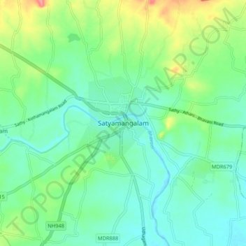
Nome: Mappa topografica Satyamangalam, altitudine, rilievo.
Altitudine media: 248 m
Altitudine minima: 224 m
Altitudine massima: 310 m
Altre mappe topografiche
Clicca su una mappa per visualizzarne la topografia, l'altitudine e il rilievo.