
Mappa topografica Snake River
Mappa interattiva
Clicca sulla mappa per visualizzare l'altitudine.
A proposito di questa mappa
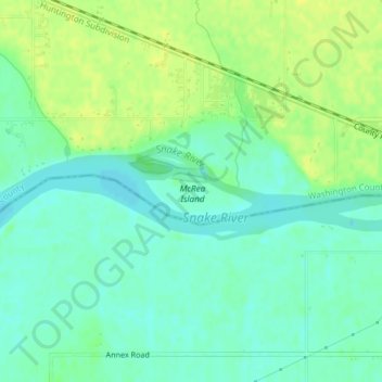
Nome: Mappa topografica Snake River, altitudine, rilievo.
Altitudine media: 644 m
Altitudine minima: 635 m
Altitudine massima: 653 m
Mountain ranges in the Snake watershed include the Teton Range, Bitterroot Range, Clearwater Mountains, Seven Devils Mountains, and the extreme northwestern end of the Wind River Range. Grand Teton is the highest point in the Snake River watershed, reaching 13,775 feet (4,199 m) in elevation. The elevation of the Snake River is 358 feet (109 m) when it joins the Columbia River.
Altre mappe topografiche
Clicca su una mappa per visualizzarne la topografia, l'altitudine e il rilievo.
Sawtooth National Forest
United States of America > Idaho > Rupert
Sawtooth National Forest, Sharon Court, Rupert, Minidoka County, Idaho, 83350, United States of America
Altitudine media: 1’608 m
Genesee
United States of America > Idaho > Genesee
Genesee, Latah County, Idaho, 83832, United States of America
Altitudine media: 824 m
Butte County
United States of America > Idaho
Butte County, Idaho, United States of America
Altitudine media: 1’914 m
Chinese Peak
United States of America > Idaho
Chinese Peak, Bannock County, Idaho, United States of America
Altitudine media: 1’830 m
Camas County
United States of America > Idaho
Camas County, Idaho, United States of America
Altitudine media: 2’002 m
Eagle Rock
United States of America > Idaho
Eagle Rock, Idaho County, Idaho, United States of America
Altitudine media: 1’164 m
Teton
United States of America > Idaho > Teton
Teton, Fremont County, Idaho, 83451, United States of America
Altitudine media: 1’509 m
Springston
United States of America > Idaho
Springston, Kootenai County, Idaho, 83833, United States of America
Altitudine media: 721 m