
Mappa topografica Niagara River
Mappa interattiva
Clicca sulla mappa per visualizzare l'altitudine.
A proposito di questa mappa
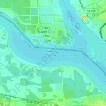
Nome: Mappa topografica Niagara River, altitudine, rilievo.
Altitudine media: 177 m
Altitudine minima: 171 m
Altitudine massima: 203 m
The river, which is occasionally described as a strait, is about 58 kilometres (36 mi) long and includes Niagara Falls in its course. The falls have moved approximately 11 kilometres (6.8 mi) upstream from the Niagara Escarpment in the last 12,000 years, resulting in a gorge below the falls. Today, the diversion of the river for electrical generation has significantly reduced the rate of erosion. The total drop in elevation along the river is 99 metres (325 ft). The Niagara Gorge extends downstream from the Falls and includes the Niagara Whirlpool and another section of rapids.
Altre mappe topografiche
Clicca su una mappa per visualizzarne la topografia, l'altitudine e il rilievo.
Crystal Beach
Canada > Ontario > Niagara Region > Fort Erie
Crystal Beach, Fort Erie, Niagara Region, Golden Horseshoe, Ontario, L0S 1B0, Canada
Altitudine media: 181 m
Fort Erie
Canada > Ontario > Niagara Region > Fort Erie
Fort Erie, Niagara Region, Golden Horseshoe, Ontario, L2A 3S7, Canada
Altitudine media: 183 m
Stevensville
Canada > Ontario > Niagara Region > Fort Erie > Stevensville
Stevensville, Fort Erie, Niagara Region, Golden Horseshoe, Ontario, Canada
Altitudine media: 178 m