
Fai una donazione
Equipaggiati per la tua prossima avventura:
In qualità di Affiliato Amazon, questo sito riceve una commissione sugli acquisti idonei, senza costi aggiuntivi per l’utente.
Mappa topografica Unionville
Clicca sulla mappa per visualizzare l'altitudine.
Fai una donazione
Equipaggiati per la tua prossima avventura:
In qualità di Affiliato Amazon, questo sito riceve una commissione sugli acquisti idonei, senza costi aggiuntivi per l’utente.
A proposito di questa mappa
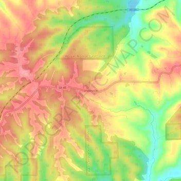
Nome: Mappa topografica Unionville, altitudine, rilievo.
Luogo: Unionville, Monroe County, Indiana, 47468, United States (39.21005 -86.43611 39.25005 -86.39611)
Altitudine media: 241 m
Altitudine minima: 183 m
Altitudine massima: 279 m
Fai una donazione
Equipaggiati per la tua prossima avventura:
In qualità di Affiliato Amazon, questo sito riceve una commissione sugli acquisti idonei, senza costi aggiuntivi per l’utente.
Altre mappe topografiche
Clicca su una mappa per visualizzarne la topografia, l'altitudine e il rilievo.
Bloomington
United States > Indiana > Monroe County
Bloomington is an area of irregular limestone terrain characterized by sinks, ravines, fissures, underground streams, sinking streams, springs and caves. It is in the rolling hills of southern Indiana, resting on the intersection of the Norman Uplands and the Mitchell Plain. The city's relatively varied…
Altitudine media: 241 m
Fai una donazione
Equipaggiati per la tua prossima avventura:
In qualità di Affiliato Amazon, questo sito riceve una commissione sugli acquisti idonei, senza costi aggiuntivi per l’utente.
Bloomington
United States > Indiana > Monroe County
Bloomington is an area of irregular limestone terrain characterized by sinks, ravines, fissures, underground streams, sinking streams, springs and caves. It is in the rolling hills of south Central Indiana, resting on the intersection of the Norman Upland and the Mitchell Plain. The city's relatively varied…
Altitudine media: 241 m
Lake Monroe
United States > Indiana > Monroe County
Lake Monroe is a reservoir located about 10 miles (16 km) southeast of Bloomington, Indiana, United States. The lake is the largest entirely situated in Indiana with 10,750 acres (43.5 km2) of water surface area spread over the counties of Monroe and Brown. Capacity varies from 292 gigalitres (237,000…
Altitudine media: 205 m
Fai una donazione
Equipaggiati per la tua prossima avventura:
In qualità di Affiliato Amazon, questo sito riceve una commissione sugli acquisti idonei, senza costi aggiuntivi per l’utente.