
Fai una donazione
Equipaggiati per la tua prossima avventura:
In qualità di Affiliato Amazon, questo sito riceve una commissione sugli acquisti idonei, senza costi aggiuntivi per l’utente.
Mappa topografica Lake Louise
Clicca sulla mappa per visualizzare l'altitudine.
Fai una donazione
Equipaggiati per la tua prossima avventura:
In qualità di Affiliato Amazon, questo sito riceve una commissione sugli acquisti idonei, senza costi aggiuntivi per l’utente.
Lake Louise
Lake Louise is a hamlet within Banff National Park in Alberta, Canada. Named after Princess Louise, Duchess of Argyll, it lies in Alberta's Rockies on the Bow River, 3 km (1.9 mi) northeast of the lake that shares its name. Initially settled in 1884 as an outpost for the Canadian Pacific Railway, Lake Louise sits at an elevation of 1,600 m (5,200 ft), making it Canada's highest community.
Fai una donazione
Equipaggiati per la tua prossima avventura:
In qualità di Affiliato Amazon, questo sito riceve una commissione sugli acquisti idonei, senza costi aggiuntivi per l’utente.
A proposito di questa mappa
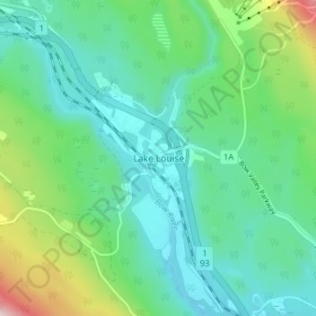
Nome: Mappa topografica Lake Louise, altitudine, rilievo.
Luogo: Lake Louise, Improvement District No. 9, Alberta, Canada (51.40497 -116.19754 51.44497 -116.15754)
Altitudine media: 1’617 m
Altitudine minima: 1’518 m
Altitudine massima: 1’934 m
Fai una donazione
Equipaggiati per la tua prossima avventura:
In qualità di Affiliato Amazon, questo sito riceve una commissione sugli acquisti idonei, senza costi aggiuntivi per l’utente.
Altre mappe topografiche
Clicca su una mappa per visualizzarne la topografia, l'altitudine e il rilievo.
Fai una donazione
Equipaggiati per la tua prossima avventura:
In qualità di Affiliato Amazon, questo sito riceve una commissione sugli acquisti idonei, senza costi aggiuntivi per l’utente.
Moraine Lake
Canada > Alberta > Improvement District No. 9
Moraine Lake is a snow and glacially fed alpine lake in Banff National Park, 14 kilometres (8.7 mi) outside the village of Lake Louise, Alberta, Canada. It is situated in the Valley of the Ten Peaks, at an elevation of approximately 1,884 metres (6,181 ft). The lake has a surface area of 50 hectares (120…
Altitudine media: 2’101 m
Fai una donazione
Equipaggiati per la tua prossima avventura:
In qualità di Affiliato Amazon, questo sito riceve una commissione sugli acquisti idonei, senza costi aggiuntivi per l’utente.
Peyto Glacier
Canada > Alberta > Improvement District No. 9 > Area A (Kicking Horse/Kinbasket Lake)
Altitudine media: 2’641 m
Fai una donazione
Equipaggiati per la tua prossima avventura:
In qualità di Affiliato Amazon, questo sito riceve una commissione sugli acquisti idonei, senza costi aggiuntivi per l’utente.
Fai una donazione
Equipaggiati per la tua prossima avventura:
In qualità di Affiliato Amazon, questo sito riceve una commissione sugli acquisti idonei, senza costi aggiuntivi per l’utente.
Moraine Lake
Canada > Alberta > Improvement District No. 9
Moraine Lake is a snow and glacially fed alpine lake in Banff National Park, 14 kilometres (8.7 mi) outside the village of Lake Louise, Alberta, Canada. It is situated in the Valley of the Ten Peaks, at an elevation of approximately 1,884 metres (6,181 ft). The lake has a surface area of 50 hectares (120…
Altitudine media: 2’101 m
Fai una donazione
Equipaggiati per la tua prossima avventura:
In qualità di Affiliato Amazon, questo sito riceve una commissione sugli acquisti idonei, senza costi aggiuntivi per l’utente.
Johnston Creek
Canada > Alberta > Improvement District No. 9
Johnston Creek originates north of Castle Mountain in a glacial valley southwest of Badger Pass and south of Pulsatilla Pass, at an elevation of 2,500 meters (8,200 ft). The creek flows southeast between Helena Ridge and the Sawback Range, and then south through a gorge known as Johnston Canyon. The stream…
Altitudine media: 2’135 m