
Mappa topografica Hull
Clicca sulla mappa per visualizzare l'altitudine.
Hull
Kingston upon Hull is on the northern bank of the Humber Estuary. The city centre is west of the River Hull and close to the Humber. The city is built upon alluvial and glacial deposits which overlie chalk rocks but the underlying chalk has no influence on the topography. The land within the city is generally very flat and is only 2 to 4 metres (6.5 to 13 ft) above sea level. Because of the relative flatness of the site there are few physical constraints upon building and many open areas are the subject of pressures to build.
A proposito di questa mappa
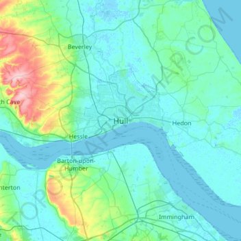
Nome: Mappa topografica Hull, altitudine, rilievo.
Altitudine media: 21 m
Altitudine minima: -4 m
Altitudine massima: 168 m