
Fai una donazione
Equipaggiati per la tua prossima avventura:
In qualità di Affiliato Amazon, questo sito riceve una commissione sugli acquisti idonei, senza costi aggiuntivi per l’utente.
Mappa topografica Wytheville
Clicca sulla mappa per visualizzare l'altitudine.
Fai una donazione
Equipaggiati per la tua prossima avventura:
In qualità di Affiliato Amazon, questo sito riceve una commissione sugli acquisti idonei, senza costi aggiuntivi per l’utente.
Wytheville
Due to its elevation, the climate of Wytheville is either classified as mountain temperate or humid subtropical (Köppen Cfb or Cfa, respectively), and the town straddles the border between USDA Plant Hardiness Zones 6B and 7A. Summers are warm and humid, although significantly cooler than low-elevation places within the state, with only 4.6 days of 90 °F (32 °C)+ highs annually, and winters are generally cool to cold with occasional intervening warm periods and 11 nights of sub-10 °F (−12 °C) lows. Monthly mean temperatures range from 32.9 °F (0.5 °C) in January to 71.7 °F (22.1 °C) in July. Snowfall averages 20.5 inches (52 cm) per season and generally occurs from December to March.
Fai una donazione
Equipaggiati per la tua prossima avventura:
In qualità di Affiliato Amazon, questo sito riceve una commissione sugli acquisti idonei, senza costi aggiuntivi per l’utente.
A proposito di questa mappa
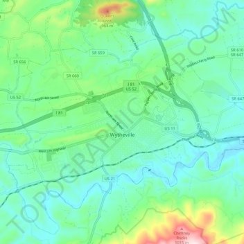
Nome: Mappa topografica Wytheville, altitudine, rilievo.
Luogo: Wytheville, Wythe County, Virginia, 24382, United States (36.92258 -81.13589 36.98165 -81.03117)
Altitudine media: 720 m
Altitudine minima: 621 m
Altitudine massima: 1’059 m
Fai una donazione
Equipaggiati per la tua prossima avventura:
In qualità di Affiliato Amazon, questo sito riceve una commissione sugli acquisti idonei, senza costi aggiuntivi per l’utente.
Altre mappe topografiche
Clicca su una mappa per visualizzarne la topografia, l'altitudine e il rilievo.
Fai una donazione
Equipaggiati per la tua prossima avventura:
In qualità di Affiliato Amazon, questo sito riceve una commissione sugli acquisti idonei, senza costi aggiuntivi per l’utente.
Stones Mill
United States > Virginia > Wythe County > Wytheville > Stones Mill
Altitudine media: 710 m
Fai una donazione
Equipaggiati per la tua prossima avventura:
In qualità di Affiliato Amazon, questo sito riceve una commissione sugli acquisti idonei, senza costi aggiuntivi per l’utente.