
Mappa topografica Hohenroda
Clicca sulla mappa per visualizzare l'altitudine.
Hohenroda
The municipality lies between the Rhön and the Thuringian Forest (ranges) in the so-called Kuppen Rhön. The highest elevation in the Hessian Skittles (a range of volcanic mountains), the Soisberg, stands at the western municipal limits.
A proposito di questa mappa
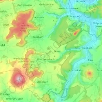
Nome: Mappa topografica Hohenroda, altitudine, rilievo.
Luogo: Hohenroda, Landkreis Hersfeld-Rotenburg, Hesse, 36284, Germany (50.76734 9.88665 50.86051 9.97804)
Altitudine media: 341 m
Altitudine minima: 215 m
Altitudine massima: 620 m
Altre mappe topografiche
Clicca su una mappa per visualizzarne la topografia, l'altitudine e il rilievo.
Bad Hersfeld
Germany > Hesse > Landkreis Hersfeld-Rotenburg
The Flugplatz Johannesberg has the status of Special Airfield. The runway, some 671 m long and 18 m wide, is paved with asphalt and oriented in a north–south direction. The airfield lies on the Johannesberg in the like-named outlying centre at an elevation of 284 m above sea level.
Altitudine media: 281 m