
Fai una donazione
Equipaggiati per la tua prossima avventura:
In qualità di Affiliato Amazon, questo sito riceve una commissione sugli acquisti idonei, senza costi aggiuntivi per l’utente.
Mappa topografica Chittoor
Clicca sulla mappa per visualizzare l'altitudine.
Fai una donazione
Equipaggiati per la tua prossima avventura:
In qualità di Affiliato Amazon, questo sito riceve una commissione sugli acquisti idonei, senza costi aggiuntivi per l’utente.
Chittoor
It is located between the northern latitudes of 37" and 14°8" and between the eastern longitudes 78°33" and 79°55". It is bounded on the east by Tirupati district of Andhra Pradesh, on the south by Krishnagiri District, Vellore, Tiruvallur, Thirupattur districts of Tamil Nadu, on the west by Kolar district of Karnataka, and on the north by Annamayya district of Andhra Pradesh. In respect of area it takes the eighth place with an area of 15,150 square kilometers which accounts for 5.51 percent of the total area of the state. The general elevation of the mountainous part of the district is 2500 feet above sea level. Chennai & Bangalore cities are located in 150 km. and 165 km. respectively from Chittoor Town. Vellore is the nearest city and twin city located 30 kms across the border with Tamil Nadu.
Fai una donazione
Equipaggiati per la tua prossima avventura:
In qualità di Affiliato Amazon, questo sito riceve una commissione sugli acquisti idonei, senza costi aggiuntivi per l’utente.
A proposito di questa mappa
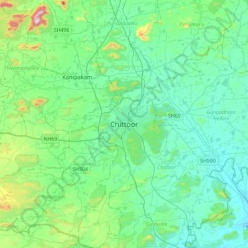
Nome: Mappa topografica Chittoor, altitudine, rilievo.
Luogo: Chittoor, Andhra Pradesh, 517001, India (13.05612 78.93728 13.37612 79.25728)
Altitudine media: 350 m
Altitudine minima: 226 m
Altitudine massima: 933 m
Fai una donazione
Equipaggiati per la tua prossima avventura:
In qualità di Affiliato Amazon, questo sito riceve una commissione sugli acquisti idonei, senza costi aggiuntivi per l’utente.