
Mappa topografica Puducherry
Clicca sulla mappa per visualizzare l'altitudine.
A proposito di questa mappa
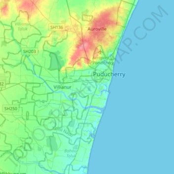
Nome: Mappa topografica Puducherry, altitudine, rilievo.
Luogo: Puducherry, India (11.77523 79.59942 12.05098 79.87460)
Altitudine media: 12 m
Altitudine minima: -4 m
Altitudine massima: 63 m
Altre mappe topografiche
Clicca su una mappa per visualizzarne la topografia, l'altitudine e il rilievo.
Puducherry
India > Puducherry > Puducherry Taluk
The topography of Pondicherry is the same as that of coastal Tamil Nadu. Pondicherry's average elevation is at sea level and includes a number of sea inlets, referred to locally as "backwaters". Pondicherry experiences extreme coastal erosion as a result of a breakwater constructed in 1989, just to the south…
Altitudine media: 10 m