Geolocalizza

Mappa topografica Harefield

Clicca sulla mappa per visualizzare l'altitudine.

A proposito di questa mappa

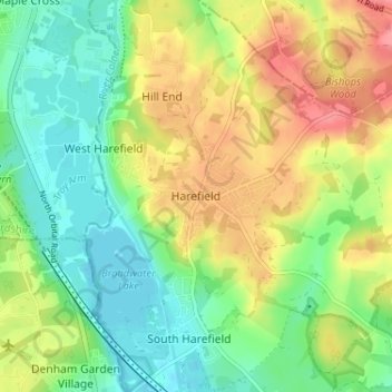
Nome: Mappa topografica Harefield, altitudine, rilievo.

Luogo: Harefield, Greater London, England, UB9 6BD, United Kingdom (51.58418 -0.50256 51.62418 -0.46256)

Altitudine media: 66 m

Altitudine minima: 35 m

Altitudine massima: 108 m

Altre mappe topografiche

Clicca su una mappa per visualizzarne la topografia, l'altitudine e il rilievo.

Bristol

United Kingdom > England > City of Bristol

Altitudine media: 55 m

Sheffield

United Kingdom > England

Sheffield nestles on the eastern foothills of the Pennines and is sculpted by a dramatic hill-and-valley system formed where five rivers — the Don, Sheaf, Rivelin, Loxley and Porter — converge, producing steep-sided valleys and gritstone ridgelines with much of the urban area built directly onto hillsides…

Altitudine media: 168 m

Greater London

United Kingdom > England

Altitudine media: 66 m

Kent

United Kingdom > England

Kent was also the location of the largest number of art schools in the country during the nineteenth century, estimated by the art historian David Haste, to approach two hundred. This is believed to be the result of Kent being a front line county during the Napoleonic Wars. At this time, before the invention…

Altitudine media: 37 m

Bath

United Kingdom > England > Bath and North East Somerset

Bath is in the Avon Valley and is surrounded by limestone hills as it is near the southern edge of the Cotswolds, a designated Area of Outstanding Natural Beauty, and the limestone Mendip Hills rise around 7 miles (11 km) south of the city. The hills that surround and make up the city have a maximum altitude…

Altitudine media: 100 m

Birmingham

United Kingdom > England

Birmingham is a snowy city relative to other large UK conurbations, due to its inland location and comparatively high elevation. Between 1961 and 1990 Birmingham Airport averaged 13.0 days of snow lying annually, compared to 5.33 at London Heathrow. Snow showers often pass through the city via the Cheshire gap…

Altitudine media: 138 m

Coventry

United Kingdom > England

Altitudine media: 99 m

North East England

United Kingdom > England

North East England has a Marine west coast climate (generally found along the west coast of middle latitude continents) with narrower temperature ranges than the south of England and sufficient precipitation in all months. Summers and winters are mild rather than extremely hot or cold, due to the strong…

Altitudine media: 165 m

Norfolk

United Kingdom > England

Altitudine media: 23 m

Nottingham

United Kingdom > England > Nottinghamshire

Altitudine media: 56 m

Southampton

United Kingdom > England

Altitudine media: 22 m

Hampshire

United Kingdom > England

Altitudine media: 73 m

Liverpool

United Kingdom > England

Altitudine media: 26 m

City of Bristol

United Kingdom > England

Altitudine media: 80 m

Lincolnshire

United Kingdom > England

Altitudine media: 28 m

Isle of Wight

United Kingdom > England

Altitudine media: 17 m

Exeter

United Kingdom > England > Devon

The city of Exeter was established on the eastern bank of the River Exe on a ridge of land backed by a steep hill. It is at this point that the Exe, having just been joined by the River Creedy, opens onto a wide flood plain and estuary which results in quite common flooding. Historically this was the lowest…

Altitudine media: 56 m

Norwich

United Kingdom > England > Norfolk

Altitudine media: 28 m

Greater Manchester

United Kingdom > England

Altitudine media: 141 m

Somerset

United Kingdom > England

Altitudine media: 87 m

Lancashire

United Kingdom > England

Altitudine media: 153 m

Guildford

United Kingdom > England > Surrey

Altitudine media: 74 m

South East England

United Kingdom > England

Near Weybridge are the UK headquarters of Sony with SSP Group (situated in Byfleet) and Procter & Gamble (next door to each other on The Heights Business Park near the former Brooklands racing circuit) with Kia Motors UK and Petroleum Geo-Services UK, and Gallaher Group (cigarettes) is to the north, next to…

Altitudine media: 69 m

Cambridge

United Kingdom > England > Cambridge

The city, like most of the UK, has a maritime climate highly influenced by the Gulf Stream. Located in the driest region of Britain, Cambridge's rainfall averages around 570 mm (22.44 in) per year, around half the national average, with some years occasionally falling into the semi-arid (under 500 mm (19.69…

Altitudine media: 18 m

Leeds

United Kingdom > England

Altitudine media: 96 m

Derbyshire

United Kingdom > England

Due to its central location in England and altitude range from 27 metres in the south to 636 metres in the north, Derbyshire contains many species at the edge of their UK distribution ranges. Some species with a predominantly northern British distribution are at the southern limit of their range, whilst others…

Altitudine media: 144 m

Dartmoor National Park

United Kingdom > England > Devon

Rainfall tends to be associated with Atlantic depressions or with convection. In summer, convection caused by solar surface heating sometimes forms shower clouds and a large proportion of rainfall falls from showers and thunderstorms at this time of year. The wettest months are November and December and on the…

Altitudine media: 239 m

Manchester

United Kingdom > England

Altitudine media: 66 m

Brighton

United Kingdom > England > Brighton and Hove

Altitudine media: 64 m

Wirral

United Kingdom > England

Altitudine media: 21 m

Herefordshire

United Kingdom > England

Altitudine media: 159 m

East of England

United Kingdom > England

The East of England region has the lowest elevation range in the UK. Twenty percent of the region is below mean sea level, most of this in North Cambridgeshire, Norfolk and on the Essex Coast. Most of the remaining area is of low elevation, with extensive glacial deposits. The Fens, a large area of reclaimed…

Altitudine media: 39 m

Lake District National Park

United Kingdom > England

The Lake District is a roughly circular upland massif, deeply dissected by a broadly radial pattern of major valleys which are largely the result of repeated glaciations over the last 2 million years. The apparent radial pattern is not from a central dome, but from an axial watershed extending from St Bees…

Altitudine media: 206 m

London

United Kingdom > England

London's topography is characterized by a gently rolling terrain shaped by the River Thames and its tributaries. The city lies within the London Basin, a natural depression bordered by higher grounds such as the North Downs to the south and the Chiltern Hills to the northwest. The Thames flows west to east,…

Altitudine media: 66 m

North Yorkshire

United Kingdom > England

Altitudine media: 153 m

Bolton

United Kingdom > England

Altitudine media: 151 m

Sunderland

United Kingdom > England

Altitudine media: 46 m

Yorkshire

United Kingdom > England

In Yorkshire there is a very close relationship between the major topographical areas and the geological period in which they were formed. The Pennine chain of hills in the west is of Carboniferous origin. The central vale is Permo-Triassic. The North York Moors in the north-east of the county are Jurassic in…

Altitudine media: 130 m

Cumbria

United Kingdom > England

Altitudine media: 186 m

Devon

United Kingdom > England

Altitudine media: 94 m

Hastings

United Kingdom > England > East Sussex

Altitudine media: 36 m

York

United Kingdom > England

Altitudine media: 16 m

North West England

United Kingdom > England

Altitudine media: 118 m

West Sussex

United Kingdom > England

Altitudine media: 52 m

Dorset

United Kingdom > England

Altitudine media: 56 m

Sussex

United Kingdom > England

Altitudine media: 39 m

Yorkshire and the Humber

United Kingdom > England

In the Yorkshire and the Humber region, there is a very close relationship between the major topographical areas and the underlying geology. The Pennine chain of hills in the west is of Carboniferous origin. The central vale is Permo-Triassic. The North York Moors in the north-east of the region are Jurassic…

Altitudine media: 120 m

City of Westminster

United Kingdom > England

The area was historically part of the county of Middlesex. Whilst an important centre of royal authority from Saxon times, Westminster was not formally incorporated as a borough for local government purposes until 1900. However, it was declared a city in 1540 on the elevation of Westminster Abbey to being a…

Altitudine media: 23 m

Stockport

United Kingdom > England

Altitudine media: 95 m

Farnham

United Kingdom > England > Surrey > Waverley

Farnham lies in the valley of the North Branch of the River Wey, which rises near Alton, merges with the South Branch at Tilford, and joins the River Thames at Weybridge. The mainly east-west alignment of the ridges and valleys has influenced the development of road and rail communications. The most prominent…

Altitudine media: 100 m

Lincoln

United Kingdom > England > Lincolnshire

Lincoln lies 157 mi (253 km) north of London, at an altitude of 67 ft (20.4 m) by the River Witham up to 246 ft (75.0 m) on Castle Hill. It fills a gap in the Lincoln Cliff escarpment, which runs north and south through central Lincolnshire, with altitudes up to 200 feet (61 metres). The city lies on the River…

Altitudine media: 29 m

Bradford

United Kingdom > England

Altitudine media: 175 m

Stoke-on-Trent

United Kingdom > England

In 1919, the borough proposed to expand further and annex the neighbouring borough of Newcastle-under-Lyme and the Wolstanton United Urban District, both to the west of Stoke. This never took place, due to strong objections from Newcastle Corporation. A further attempt was made in 1930, with the promotion of…

Altitudine media: 168 m

Windermere

United Kingdom > England > Cumbria > South Lakeland > Bowness-on-Windermere

There is debate as to whether the stretch of water between Newby Bridge and Lakeside at the southern end of the lake should be considered part of Windermere, or a navigable stretch of the River Leven. This affects the stated length of the lake, which is 11.23 miles (18.07 km) long if measured from the bridge…

Altitudine media: 132 m

Essex

United Kingdom > England

Altitudine media: 44 m

Oxford

United Kingdom > England > Oxfordshire

Altitudine media: 81 m

Oxford

United Kingdom > England > Oxfordshire

Altitudine media: 81 m

Harlow

United Kingdom > England > Essex

Altitudine media: 69 m

Knockin

United Kingdom > England > Shropshire

Altitudine media: 74 m

Chilterns National Landscape

United Kingdom > England > Buckinghamshire

The highest point is at 267 m (876 ft.) above sea level at Haddington Hill near Wendover in Buckinghamshire; a stone monument marks the summit. The nearby Ivinghoe Beacon is a more prominent hill, although its altitude is only 249 m (817 ft.). It is the starting point of the Icknield Way Path and the Ridgeway…

Altitudine media: 102 m

Kent

United Kingdom > England > Sevenoaks

Altitudine media: 37 m

Brighton and Hove

United Kingdom > England

Altitudine media: 63 m

Oxfordshire

United Kingdom > England

Altitudine media: 113 m

Dorset

United Kingdom > England > Talbot Village

Altitudine media: 57 m

Dover

United Kingdom > England > Kent

Altitudine media: 39 m

Canterbury

United Kingdom > England > Kent

Altitudine media: 51 m

Lancaster

United Kingdom > England > Lancashire

Altitudine media: 84 m

Wakefield

United Kingdom > England

Altitudine media: 88 m

Gateshead

United Kingdom > England > Tyne and Wear

Altitudine media: 81 m

Surrey Heath

United Kingdom > England > Surrey

Altitudine media: 69 m

Burrowbridge

United Kingdom > England > Somerset

Altitudine media: 7 m

East Midlands

United Kingdom > England

The highest point at 636 m (2,087 ft) is Kinder Scout, in the Peak District of the southern Pennines in northwest Derbyshire near Glossop. Other hilly areas of 95 to 280 m (312 to 919 ft) in altitude, together with lakes and reservoirs, rise in and around the Charnwood Forest north of Peterborough, Leicester,…

Altitudine media: 75 m

Wiltshire

United Kingdom > England

Altitudine media: 115 m

Staffordshire

United Kingdom > England

Altitudine media: 130 m

Suffolk

United Kingdom > England

The west of the county lies on more resistant Cretaceous chalk. This chalk is responsible for a sweeping tract of largely downland landscapes that stretches from Dorset in the south west to Dover in the south east and north through East Anglia to the Yorkshire Wolds. The chalk is less easily eroded so forms…

Altitudine media: 35 m

Oldham

United Kingdom > England

Altitudine media: 192 m

Cheltenham

United Kingdom > England > Gloucestershire

Altitudine media: 109 m

Maidstone

United Kingdom > England > Kent

Altitudine media: 70 m

Gosport

United Kingdom > England > Hampshire

Altitudine media: 3 m

Walsall

United Kingdom > England

Altitudine media: 145 m

Carlisle

United Kingdom > England > Cumberland

Altitudine media: 31 m

Bromsgrove

United Kingdom > England > Worcestershire

Altitudine media: 120 m

High Wycombe

United Kingdom > England > Buckinghamshire

Altitudine media: 124 m

Sheffield

United Kingdom > England

Sheffield nestles on the eastern foothills of the Pennines and is sculpted by a dramatic hill-and-valley system formed where five rivers — the Don, Sheaf, Rivelin, Loxley and Porter — converge, producing steep-sided valleys and gritstone ridgelines with much of the urban area built directly onto hillsides…

Altitudine media: 169 m

Sutton Coldfield

United Kingdom > England > Birmingham

Altitudine media: 124 m

Cheshire

United Kingdom > England

Altitudine media: 103 m

Medway

United Kingdom > England

Altitudine media: 31 m

East Riding of Yorkshire

United Kingdom > England

The western part of the district in the Vale of York borders on and is drained by the River Derwent. The landscape is generally low-lying and flat although minor ridges and glacial moraines provide some variations in topography. Where there are dry sandy soils there are remnants of historic heathlands and…

Altitudine media: 30 m

Equipaggiati per la tua prossima avventura:

🪓Coltello Multiuso - Coltello multifunzione compatto per outdoor
🪶Benda Antivento - Protezione antivento per testa e collo
🧴Protezione Solare Altitudine - Crema solare specifica per le forti radiazioni UV in montagna
🎒Sacca Compressione - Per ridurre volume dell’equipaggiamento
🪢Mezza Corda Alpinismo - Corda tecnica per sicurezza su ghiacciaio e creste

In qualità di Affiliato Amazon, questo sito riceve una commissione sugli acquisti idonei, senza costi aggiuntivi per l’utente.