
Fai una donazione
Equipaggiati per la tua prossima avventura:
In qualità di Affiliato Amazon, questo sito riceve una commissione sugli acquisti idonei, senza costi aggiuntivi per l’utente.
Mappa topografica Torreys Peak
Clicca sulla mappa per visualizzare l'altitudine.
Fai una donazione
Equipaggiati per la tua prossima avventura:
In qualità di Affiliato Amazon, questo sito riceve una commissione sugli acquisti idonei, senza costi aggiuntivi per l’utente.
Torreys Peak
The third trail starts at Loveland Pass about 4.5 miles (7.2 km) to the northwest. To reach Loveland Pass, follow I-70 west from Denver 55 miles (89 km) to where US Route 6 breaks off and heads south. Follow the meandering Route 6 approximately seven miles to the trailhead at Loveland Pass, at an elevation of 11,990 feet (3,650 m). The steepest part of the trail actually begins right away with a half mile climb of 1,000 feet (300 m). The trail follows the Continental Divide gently taking the climber down into three saddles and up two more peaks, including Grizzly Peak at 13,427 feet (4,093 m) and Mount Sniktau at 13,234 feet (4,034 m). The final saddle rests at approximately 12,600 ft. From this saddle, it is a mile-long ascent of 1,800 feet (550 m) to the final summit.
Fai una donazione
Equipaggiati per la tua prossima avventura:
In qualità di Affiliato Amazon, questo sito riceve una commissione sugli acquisti idonei, senza costi aggiuntivi per l’utente.
A proposito di questa mappa
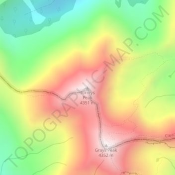
Nome: Mappa topografica Torreys Peak, altitudine, rilievo.
Luogo: Torreys Peak, Clear Creek County, Colorado, United States (39.64272 -105.82128 39.64282 -105.82118)
Altitudine media: 3’854 m
Altitudine minima: 3’365 m
Altitudine massima: 4’341 m
Fai una donazione
Equipaggiati per la tua prossima avventura:
In qualità di Affiliato Amazon, questo sito riceve una commissione sugli acquisti idonei, senza costi aggiuntivi per l’utente.
Altre mappe topografiche
Clicca su una mappa per visualizzarne la topografia, l'altitudine e il rilievo.
Georgetown
United States > Colorado > Clear Creek County
The town sits at an elevation of 8,530 feet (2,600 m) above sea level, nestled in the mountains near the upper end of the valley of Clear Creek in the mountains west of Denver along Interstate 70. Although population was only about 1,000 at the 2010 census, the town was a historic center of the mining industry…
Altitudine media: 2’974 m
Fai una donazione
Equipaggiati per la tua prossima avventura:
In qualità di Affiliato Amazon, questo sito riceve una commissione sugli acquisti idonei, senza costi aggiuntivi per l’utente.
Fai una donazione
Equipaggiati per la tua prossima avventura:
In qualità di Affiliato Amazon, questo sito riceve una commissione sugli acquisti idonei, senza costi aggiuntivi per l’utente.
Georgetown
United States > Colorado > Clear Creek County
The town sits at an elevation of 8,530 feet (2,600 m) above sea level, nestled in the mountains near the upper end of the valley of Clear Creek in the mountains west of Denver along Interstate 70. Although population was only about 1,000 at the 2010 census, the town was a historic center of the mining industry…
Altitudine media: 2’974 m