
Mappa topografica Gunnison
Mappa interattiva
Clicca sulla mappa per visualizzare l'altitudine.
A proposito di questa mappa
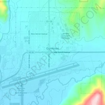
Nome: Mappa topografica Gunnison, altitudine, rilievo.
Luogo: Gunnison, Gunnison County, Colorado, United States (38.52956 -106.95098 38.55905 -106.90267)
Altitudine media: 2’369 m
Altitudine minima: 2’332 m
Altitudine massima: 2’633 m
Also in 1880, the cattle industry in Gunnison was established. Realizing the poor conditions for farming (with only about eleven inches of rainfall annually and the short growing season due to the high elevation and alpine environment) the local farmers turned to ranching and began breeding cattle. To do this effectively, they had to clear and level fields for grazing purposes. Irrigation ditches also had to be cut into the ground to properly irrigate the fields in order to grow hay for the horses and cattle. Many of these practices are still in use, which can be seen while driving through and around the town to the various ranches that are still in operation.
Altre mappe topografiche
Clicca su una mappa per visualizzarne la topografia, l'altitudine e il rilievo.
Crested Butte
United States > Colorado > Gunnison County
Crested Butte, Gunnison County, Colorado, 81224, United States
Altitudine media: 2’798 m
Gothic
United States > Colorado > Gunnison County
Gothic, Gunnison County, Colorado, United States
Altitudine media: 3’140 m
Marble
United States > Colorado > Gunnison County
Marble, Gunnison County, Colorado, United States
Altitudine media: 2’611 m
Almont
United States > Colorado > Gunnison County
Almont, Gunnison County, Colorado, United States
Altitudine media: 2’578 m
Crested Butte South
United States > Colorado > Gunnison County
Crested Butte South, Gunnison County, Colorado, United States
Altitudine media: 2’742 m
Mount Baldy
United States > Colorado > Gunnison County
Mount Baldy, Gunnison County, Colorado, United States
Altitudine media: 3’489 m