
Mappa topografica Blairsville
Mappa interattiva
Clicca sulla mappa per visualizzare l'altitudine.
Blairsville
Blairsville has a humid subtropical climate, yet due to its elevation of 1,883 feet (574 m), typically records far lower temperatures at night than what is encountered in much of the Southeastern U.S., and has slightly higher precipitation totals (56 inches or 1,420 millimetres annually) than most locations in the state; the average diurnal temperature variation exceeds 25 °F (14 °C) in each of the spring and autumn months. Snow usually occurs several times every year. The average annual snowfall is 4 inches. The monthly daily mean temperature ranges from 36.8 °F (2.7 °C) in January to 73.3 °F (22.9 °C) in July. There are 7.6 days of 90 °F (32 °C) highs and 4.6 days where the high fails to rise above freezing annually.
A proposito di questa mappa
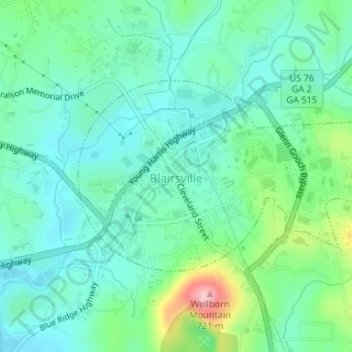
Nome: Mappa topografica Blairsville, altitudine, rilievo.
Luogo: Blairsville, Union County, Georgia, United States (34.86877 -83.96754 34.88341 -83.93990)
Altitudine media: 587 m
Altitudine minima: 542 m
Altitudine massima: 726 m
Altre mappe topografiche
Clicca su una mappa per visualizzarne la topografia, l'altitudine e il rilievo.
Blood Mountain
United States > Georgia > Union County
Blood Mountain is the highest peak on the Georgia section of the Appalachian Trail and the sixth-tallest mountain in Georgia, with an elevation of 4,458 feet (1,359 m). It is located on the border of Lumpkin County with Union County and is within the boundaries of the Chattahoochee National Forest and the…
Altitudine media: 1’048 m