
Mappa topografica Lewiston
Mappa interattiva
Clicca sulla mappa per visualizzare l'altitudine.
A proposito di questa mappa
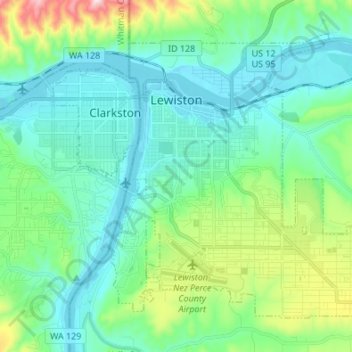
Nome: Mappa topografica Lewiston, altitudine, rilievo.
Luogo: Lewiston, Nez Perce County, Idaho, 83501, United States (46.36165 -117.04659 46.43711 -116.91126)
Altitudine media: 334 m
Altitudine minima: 219 m
Altitudine massima: 758 m
According to the U.S. Census Bureau, the city has a total area of 18.04 square miles (46.72 km2), of which 17.23 square miles (44.63 km2) is land and 0.81 square miles (2.10 km2) is water. Downtown Lewiston, at elevations between 740 feet (230 m) and 780 feet (240 m), is only slightly higher in elevation than the river, about 741 ft (226 m), which was thirty feet (9 m) lower prior to the completion of the Lower Granite Dam. Away from downtown the terrain gains elevation quickly, as the steep riverbank highway of U.S. 95 north of Lewiston ascends to 2,756 feet (840 m).
Altre mappe topografiche
Clicca su una mappa per visualizzarne la topografia, l'altitudine e il rilievo.
Peck
United States > Idaho > Nez Perce County
Peck, Nez Perce County, Idaho, United States
Altitudine media: 492 m
Lenore
United States > Idaho > Nez Perce County
Lenore, Nez Perce County, Idaho, United States
Altitudine media: 401 m
Lapwai
United States > Idaho > Nez Perce County
Lapwai, Nez Perce County, Idaho, 83540, United States
Altitudine media: 364 m
Culdesac
United States > Idaho > Nez Perce County > Culdesac
Culdesac, Nez Perce County, Idaho, United States
Altitudine media: 588 m
Upper Cache Creek Rapids
United States > Idaho > Nez Perce County
Upper Cache Creek Rapids, Nez Perce County, Idaho, United States
Altitudine media: 484 m