
Fai una donazione
Equipaggiati per la tua prossima avventura:
In qualità di Affiliato Amazon, questo sito riceve una commissione sugli acquisti idonei, senza costi aggiuntivi per l’utente.
Mappa topografica East Lyme
Clicca sulla mappa per visualizzare l'altitudine.
Fai una donazione
Equipaggiati per la tua prossima avventura:
In qualità di Affiliato Amazon, questo sito riceve una commissione sugli acquisti idonei, senza costi aggiuntivi per l’utente.
East Lyme
The topography of East Lyme consists of rolling hills and lush valleys rounded by glaciers during the last Ice Age. Hills rise to elevations of 250 to 350 feet (76 to 107 m) above sea level in the eastern and central areas of the town. The highest point in town is an unnamed hill with an elevation of 500 feet (150 m) located in Nehantic State Forest in the northwest corner of the town. East Lyme is especially scenic in the summer when the trees are in bloom. On its east and southern sides, the town abuts tidewater. The tidal Niantic River on the east feeds Niantic Bay, an arm of Long Island Sound, which forms the southern edge of the town.
Fai una donazione
Equipaggiati per la tua prossima avventura:
In qualità di Affiliato Amazon, questo sito riceve una commissione sugli acquisti idonei, senza costi aggiuntivi per l’utente.
A proposito di questa mappa
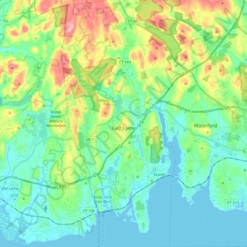
Nome: Mappa topografica East Lyme, altitudine, rilievo.
Altitudine media: 41 m
Altitudine minima: -3 m
Altitudine massima: 152 m
Fai una donazione
Equipaggiati per la tua prossima avventura:
In qualità di Affiliato Amazon, questo sito riceve una commissione sugli acquisti idonei, senza costi aggiuntivi per l’utente.
Altre mappe topografiche
Clicca su una mappa per visualizzarne la topografia, l'altitudine e il rilievo.
High Rock
United States > Connecticut > Southeastern Connecticut Planning Region > Waterford
Altitudine media: 39 m
Chesterfield
United States > Connecticut > Southeastern Connecticut Planning Region > Montville
Altitudine media: 77 m
North Franklin
United States > Connecticut > Southeastern Connecticut Planning Region
Altitudine media: 103 m
Fai una donazione
Equipaggiati per la tua prossima avventura:
In qualità di Affiliato Amazon, questo sito riceve una commissione sugli acquisti idonei, senza costi aggiuntivi per l’utente.
Flanders
United States > Connecticut > Southeastern Connecticut Planning Region > East Lyme
Altitudine media: 43 m
Manitock Spring
United States > Connecticut > Southeastern Connecticut Planning Region > Waterford
Altitudine media: 26 m
Quiambaug
United States > Connecticut > Southeastern Connecticut Planning Region > Mystic
Altitudine media: 8 m
Oakdale
United States > Connecticut > Southeastern Connecticut Planning Region > Montville
Altitudine media: 141 m
Fai una donazione
Equipaggiati per la tua prossima avventura:
In qualità di Affiliato Amazon, questo sito riceve una commissione sugli acquisti idonei, senza costi aggiuntivi per l’utente.
Austrailia Beach
United States > Connecticut > Southeastern Connecticut Planning Region > Mystic
Altitudine media: 19 m
Jordan Village
United States > Connecticut > Southeastern Connecticut Planning Region > Waterford
Altitudine media: 27 m
Giants Neck
United States > Connecticut > Southeastern Connecticut Planning Region > East Lyme
Altitudine media: 9 m
Flanders
United States > Connecticut > Southeastern Connecticut Planning Region > East Lyme
Altitudine media: 38 m
Fai una donazione
Equipaggiati per la tua prossima avventura:
In qualità di Affiliato Amazon, questo sito riceve una commissione sugli acquisti idonei, senza costi aggiuntivi per l’utente.
Pepperbox Hill
United States > Connecticut > Southeastern Connecticut Planning Region > Waterford
Altitudine media: 18 m
Austrailia Beach
United States > Connecticut > Southeastern Connecticut Planning Region > Mystic
Altitudine media: 19 m
Montville Center
United States > Connecticut > Southeastern Connecticut Planning Region > Montville
Altitudine media: 106 m
Four Corners
United States > Connecticut > Southeastern Connecticut Planning Region > Montville
Altitudine media: 108 m
Fai una donazione
Equipaggiati per la tua prossima avventura:
In qualità di Affiliato Amazon, questo sito riceve una commissione sugli acquisti idonei, senza costi aggiuntivi per l’utente.
Taftville Reservoir #1 Dam
United States > Connecticut > Southeastern Connecticut Planning Region > Norwich
Altitudine media: 75 m
Blue Lake
United States > Connecticut > Southeastern Connecticut Planning Region > North Stonington
Altitudine media: 106 m
Blackboys
United States > Connecticut > Southeastern Connecticut Planning Region > East Lyme
Altitudine media: 38 m
Fai una donazione
Equipaggiati per la tua prossima avventura:
In qualità di Affiliato Amazon, questo sito riceve una commissione sugli acquisti idonei, senza costi aggiuntivi per l’utente.
Quiambaug
United States > Connecticut > Southeastern Connecticut Planning Region > Mystic
Altitudine media: 8 m
Quaker Hill
United States > Connecticut > Southeastern Connecticut Planning Region > Waterford
Altitudine media: 35 m
Center Groton
United States > Connecticut > Southeastern Connecticut Planning Region > Groton
Altitudine media: 49 m
Uncasville
United States > Connecticut > Southeastern Connecticut Planning Region > Montville
Altitudine media: 40 m
Fai una donazione
Equipaggiati per la tua prossima avventura:
In qualità di Affiliato Amazon, questo sito riceve una commissione sugli acquisti idonei, senza costi aggiuntivi per l’utente.
Chesterfield
United States > Connecticut > Southeastern Connecticut Planning Region > Montville
Altitudine media: 77 m
Austrailia Beach
United States > Connecticut > Southeastern Connecticut Planning Region > Mystic
Altitudine media: 19 m
Huntley Island
United States > Connecticut > Southeastern Connecticut Planning Region > East Lyme
Altitudine media: 7 m
Austrailia Beach
United States > Connecticut > Southeastern Connecticut Planning Region > Mystic
Altitudine media: 19 m
Fai una donazione
Equipaggiati per la tua prossima avventura:
In qualità di Affiliato Amazon, questo sito riceve una commissione sugli acquisti idonei, senza costi aggiuntivi per l’utente.
Hanover Reservoir
United States > Connecticut > Southeastern Connecticut Planning Region > Hanover
Altitudine media: 91 m
North Stonington
United States > Connecticut > Southeastern Connecticut Planning Region
Altitudine media: 73 m
Mystic
United States > Connecticut > Southeastern Connecticut Planning Region > Stonington
Altitudine media: 17 m
Avery Hill
United States > Connecticut > Southeastern Connecticut Planning Region > Ledyard
Altitudine media: 52 m
Fai una donazione
Equipaggiati per la tua prossima avventura:
In qualità di Affiliato Amazon, questo sito riceve una commissione sugli acquisti idonei, senza costi aggiuntivi per l’utente.
Fitch Corner
United States > Connecticut > Southeastern Connecticut Planning Region > Montville
Altitudine media: 51 m
Seal Rocks
United States > Connecticut > Southeastern Connecticut Planning Region > Stonington
Altitudine media: 37 m