
Mappa topografica Kennesaw
Mappa interattiva
Clicca sulla mappa per visualizzare l'altitudine.
A proposito di questa mappa
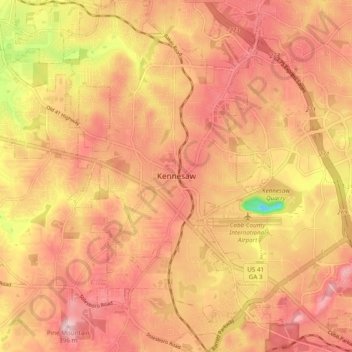
Nome: Mappa topografica Kennesaw, altitudine, rilievo.
Luogo: Kennesaw, Cobb County, Georgia, 30144, United States (33.98343 -84.65549 34.06343 -84.57549)
Altitudine media: 318 m
Altitudine minima: 167 m
Altitudine massima: 393 m
Kennesaw is located in northwestern Cobb County, bordered by the city of Acworth to the northwest. Kennesaw Mountain is located southeast of the city limits in the battlefield park. Its summit is the highest point in the Atlanta metro area, at an elevation of 1,808 feet (551 m) above sea level. The city was renamed for the mountain.