
Mappa topografica Alderley Edge
Clicca sulla mappa per visualizzare l'altitudine.
Alderley Edge
Alderley Edge is 6 miles (10 km) northwest of Macclesfield and 12 miles (19 km) south of Manchester, at the base of a steep and thickly wooded sandstone escarpment, Alderley Edge, which is the area's chief topographical feature and overlooks the Cheshire Plain.
A proposito di questa mappa
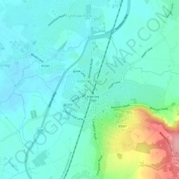
Nome: Mappa topografica Alderley Edge, altitudine, rilievo.
Luogo: Alderley Edge, Cheshire East, England, United Kingdom (53.29448 -2.25853 53.31426 -2.20820)
Altitudine media: 91 m
Altitudine minima: 63 m
Altitudine massima: 194 m
Altre mappe topografiche
Clicca su una mappa per visualizzarne la topografia, l'altitudine e il rilievo.
Whirley Grove
United Kingdom > England > Cheshire East > Macclesfield > Whirley Grove
Altitudine media: 154 m
Peckforton Moss
United Kingdom > England > Cheshire East > Bulkeley > Peckforton
Altitudine media: 100 m
Shining Tor
United Kingdom > England > Cheshire East
Shining Tor is the highest hill in Cheshire, England. The summit has an elevation of 559 m (1,834 ft) above sea level. It is in the Peak District, between the towns of Macclesfield in Cheshire and Buxton in Derbyshire, and is on the administrative boundary between Derbyshire and Cheshire East. The hill is at…
Altitudine media: 440 m
Higher Poynton
United Kingdom > England > Cheshire East > Poynton > Higher Poynton
Altitudine media: 157 m