
Mappa topografica Vanderbijlpark
Mappa interattiva
Clicca sulla mappa per visualizzare l'altitudine.
A proposito di questa mappa
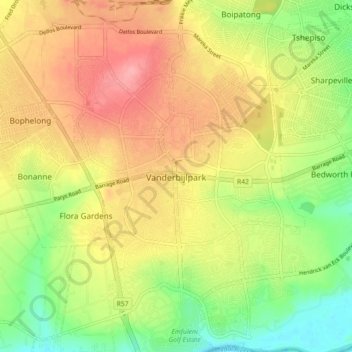
Nome: Mappa topografica Vanderbijlpark, altitudine, rilievo.
Altitudine media: 1’474 m
Altitudine minima: 1’421 m
Altitudine massima: 1’525 m
Vanderbijlpark is situated on the highveld of South Africa, at an altitude of 1,500 meters on the banks of the Vaal River. Summers in the city are warm to hot with an average high between 31 and 35°C, and an average low between 15 and 22°C. Winters in the city are cool to warm with an average high of between 18 and 23°C and an average low of between −1 and 5°C.
Altre mappe topografiche
Clicca su una mappa per visualizzarne la topografia, l'altitudine e il rilievo.
Evaton
South Africa > Gauteng > Sedibeng District Municipality > Emfuleni Local Municipality
Evaton, Emfuleni Local Municipality, Sedibeng District Municipality, Gauteng, South Africa
Altitudine media: 1’522 m
Sebokeng
South Africa > Gauteng > Sedibeng District Municipality > Emfuleni Local Municipality
Sebokeng, Emfuleni Local Municipality, Sedibeng District Municipality, Gauteng, 1984, South Africa
Altitudine media: 1’523 m