
Mappa topografica Newington
Mappa interattiva
Clicca sulla mappa per visualizzare l'altitudine.
A proposito di questa mappa
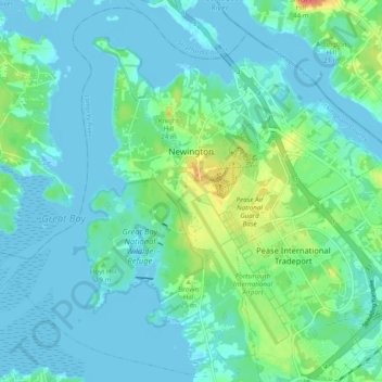
Nome: Mappa topografica Newington, altitudine, rilievo.
Luogo: Newington, Rockingham County, New Hampshire, United States (43.05903 -70.87996 43.12711 -70.78283)
Altitudine media: 10 m
Altitudine minima: -7 m
Altitudine massima: 47 m
According to the United States Census Bureau, the town has a total area of 12.4 square miles (32.0 km2), of which 8.1 square miles (21.0 km2) are land and 4.2 square miles (11.0 km2) are water, comprising 34.5% of the town. The highest elevation in Newington is 130 feet (40 m) above sea level, near Newington Cemetery in the center of town.
Altre mappe topografiche
Clicca su una mappa per visualizzarne la topografia, l'altitudine e il rilievo.
Jenness Beach
United States > New Hampshire > Rockingham County > Rye > Rye Beach Village District
Jenness Beach, Rye Beach Village District, Rye, Rockingham County, New Hampshire, United States
Altitudine media: 5 m
Northwood
United States > New Hampshire > Rockingham County
Northwood, Rockingham County, New Hampshire, 03261, United States
Altitudine media: 167 m
Portsmouth
United States > New Hampshire > Rockingham County
Portsmouth, Rockingham County, New Hampshire, United States
Altitudine media: 9 m
Stratham
United States > New Hampshire > Rockingham County
Stratham, Rockingham County, New Hampshire, 03885, United States
Altitudine media: 22 m