
Fai una donazione
Equipaggiati per la tua prossima avventura:
In qualità di Affiliato Amazon, questo sito riceve una commissione sugli acquisti idonei, senza costi aggiuntivi per l’utente.
Mappa topografica Mercer Island
Clicca sulla mappa per visualizzare l'altitudine.
Fai una donazione
Equipaggiati per la tua prossima avventura:
In qualità di Affiliato Amazon, questo sito riceve una commissione sugli acquisti idonei, senza costi aggiuntivi per l’utente.
Mercer Island
Mercer Island City Hall is located at 47°34′39″N 122°12′43.2″W / 47.57750°N 122.212000°W / 47.57750; -122.212000 (47.5775, -122.212). The peak elevation in the city is about 338 feet (103 m), near the center of the island.
Fai una donazione
Equipaggiati per la tua prossima avventura:
In qualità di Affiliato Amazon, questo sito riceve una commissione sugli acquisti idonei, senza costi aggiuntivi per l’utente.
A proposito di questa mappa
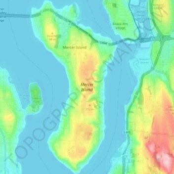
Nome: Mappa topografica Mercer Island, altitudine, rilievo.
Altitudine media: 39 m
Altitudine minima: -3 m
Altitudine massima: 176 m
Fai una donazione
Equipaggiati per la tua prossima avventura:
In qualità di Affiliato Amazon, questo sito riceve una commissione sugli acquisti idonei, senza costi aggiuntivi per l’utente.