
Mappa topografica Norwalk
Mappa interattiva
Clicca sulla mappa per visualizzare l'altitudine.
A proposito di questa mappa
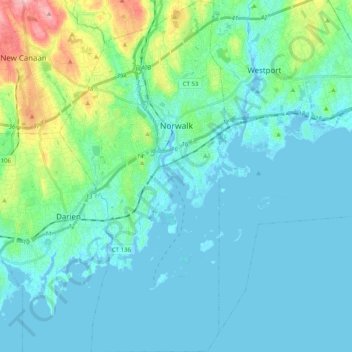
Nome: Mappa topografica Norwalk, altitudine, rilievo.
Luogo: Norwalk, Western Connecticut COG, Connecticut, United States (41.02045 -73.47457 41.17127 -73.38029)
Altitudine media: 24 m
Altitudine minima: -7 m
Altitudine massima: 145 m
Norwalk's topography is dominated by its coastline along Long Island Sound, the Norwalk River and its eastern and western banks, and the Norwalk Islands. The highest elevation is 315 feet (96 m) above sea level on the fairway of the 16th hole of the Silvermine Golf Course, and the low elevation is sea level on Long Island Sound.