
Fai una donazione
Equipaggiati per la tua prossima avventura:
In qualità di Affiliato Amazon, questo sito riceve una commissione sugli acquisti idonei, senza costi aggiuntivi per l’utente.
Mappa topografica Earp
Clicca sulla mappa per visualizzare l'altitudine.
Fai una donazione
Equipaggiati per la tua prossima avventura:
In qualità di Affiliato Amazon, questo sito riceve una commissione sugli acquisti idonei, senza costi aggiuntivi per l’utente.
A proposito di questa mappa
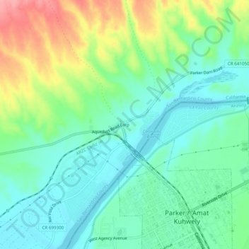
Nome: Mappa topografica Earp, altitudine, rilievo.
Altitudine media: 137 m
Altitudine minima: 104 m
Altitudine massima: 209 m
Fai una donazione
Equipaggiati per la tua prossima avventura:
In qualità di Affiliato Amazon, questo sito riceve una commissione sugli acquisti idonei, senza costi aggiuntivi per l’utente.
Altre mappe topografiche
Clicca su una mappa per visualizzarne la topografia, l'altitudine e il rilievo.
San Bernardino National Forest
United States > California > San Bernardino County
The San Bernardino National Forest is a United States national forest in Southern California encompassing 823,816 acres (3,333.87 km2) of which 677,982 acres (2,743.70 km2) are federal. The forest is made up of two main divisions, the eastern portion of the San Gabriel Mountains and the San Bernardino…
Altitudine media: 1’009 m
Fai una donazione
Equipaggiati per la tua prossima avventura:
In qualità di Affiliato Amazon, questo sito riceve una commissione sugli acquisti idonei, senza costi aggiuntivi per l’utente.
Twentynine Palms
United States > California > San Bernardino County
According to the United States Census Bureau, the city has a total area of 59.1 square miles (153 km2), all land. The city is at an elevation of 1,988 feet (606 m). The Marine Corps Air Ground Combat Center Twentynine Palms is located there.
Altitudine media: 690 m
Rialto
United States > California > San Bernardino County
The particularly arid climate during the summer prevents tropospheric clouds from forming, meaning temperatures rise to what is considered Class Orange by NOAA. Rialto gets an average of 16 inches (410 mm) of rain, and most of this rainfall precipitates in winter. During winter, Rialto's northernmost…
Altitudine media: 391 m
Fai una donazione
Equipaggiati per la tua prossima avventura:
In qualità di Affiliato Amazon, questo sito riceve una commissione sugli acquisti idonei, senza costi aggiuntivi per l’utente.
Twentynine Palms
United States > California > San Bernardino County > Twentynine Palms
According to the United States Census Bureau, the city has a total area of 59.1 square miles (153 km2), all land. The city is at an elevation of 1,988 feet (606 m). The Marine Corps Air Ground Combat Center Twentynine Palms is located there.
Altitudine media: 690 m
Upland
United States > California > San Bernardino County > Upland
Upland is a city in San Bernardino County, California, United States on the border with neighboring Los Angeles County. The municipality is located at an elevation of 1,242 feet (379 m). As of the 2020 census, the city had a population of 79,040, up from 73,732 at the 2010 census and 68,393 at the 2000 census.…
Altitudine media: 457 m